Hadrian’s Wall is in northern England, stretching 118 kilometres from Wallsend on the River Tyne to Bowness-on-Solway. The Romans began building it around AD 122 to strengthen their frontier, slow raiders and regulate movement and trade through controlled crossings.
Why did this frontier need gateways as well as barriers? Its small forts connected northern and southern entrances, while nearby towers housed soldiers on watch. If you follow those connections, the Wall becomes easier to understand: its route, defences and daily routines belonged to one working system.
When and along which route was Hadrian’s Wall built?
Construction is associated with Emperor Hadrian’s visit to Britain in AD 122. Completing the Wall took at least six years. Soldiers from three legions stationed in Britain worked on it: II Augusta, VI Victrix and XX Valeria Victrix. The building effort therefore involved several military formations.
The route crossed northern England between Wallsend in the east and Bowness-on-Solway in the west. UNESCO gives its length as 118 kilometres. Those endpoints locate the frontier more precisely than the common description of a Roman wall somewhere near Scotland.
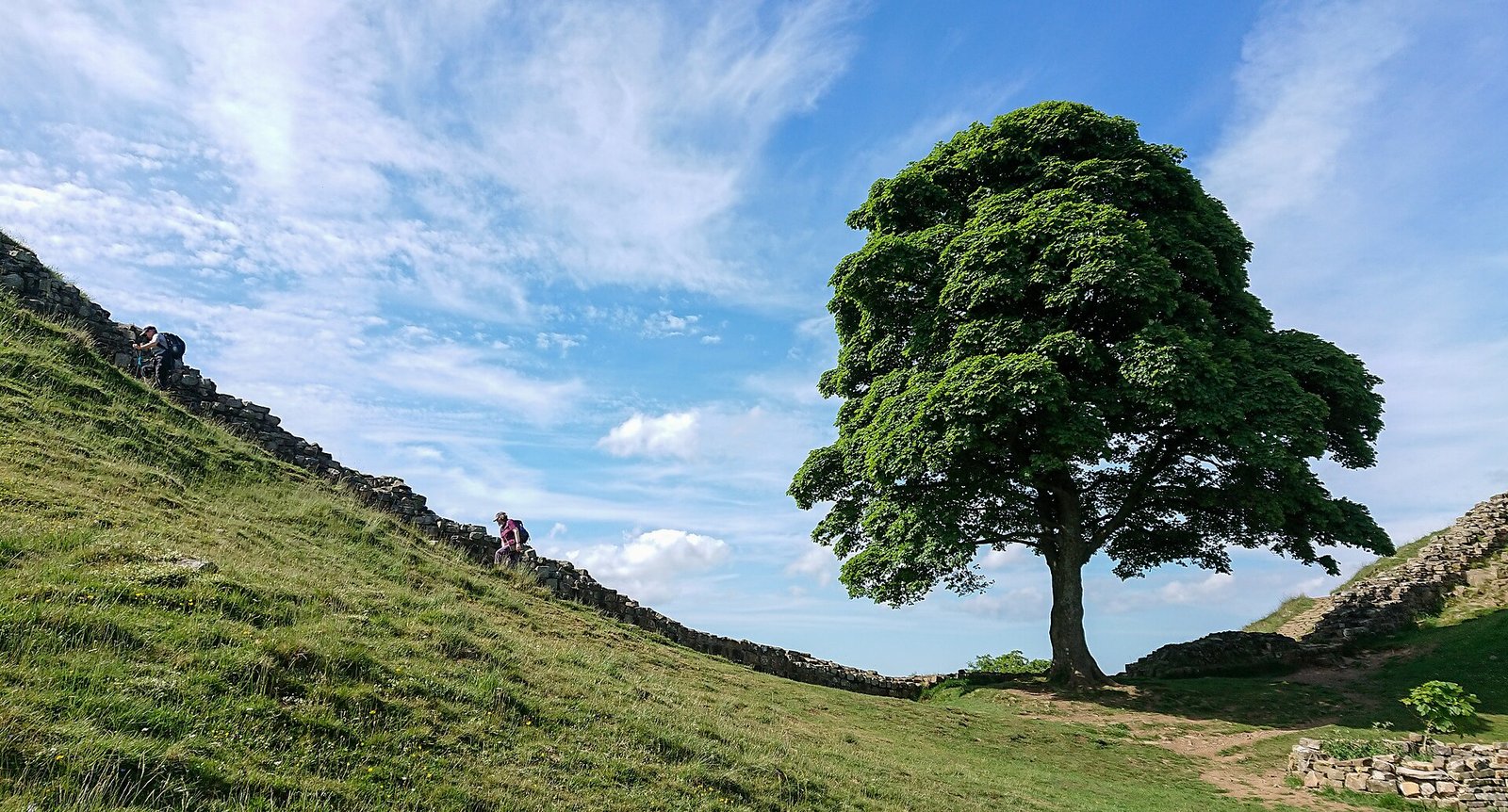
In the central section, between Sewingshields and Walltown, the Wall followed the north-facing cliffs of the Whin Sill. Steep ground supplied a natural obstacle. Elsewhere, a large ditch north of the Wall added protection. The relationship between masonry and terrain changed along the route.
The western section also had a different beginning. Between the River Irthing and the Solway Firth, builders initially used turf blocks. Stone later replaced this turf wall. If you picture the entire frontier as a stone structure from its first day, this western stretch requires a different picture.
Changes continued during construction. Before the original plan was complete, 14 large forts were added to the Wall line. Their introduction altered the initial arrangement of small forts and towers. The surviving frontier reflects decisions made while the project was already under way.
What were its roles in defence, movement control and trade?
Hadrian’s Wall was a major element of the Roman Empire’s northwestern frontier for about 300 years. Its defensive role depended on more than the wall itself. Ditches, natural cliffs, watch points and nearby forts contributed to a system that could obstruct movement and support a military response.
Archaeologist Nick Hodgson argues that physical barriers slowed groups crossing the frontier to raid. That delay gave nearby forts time to send reinforcements. In this interpretation, the Wall’s main defensive value lay in making a crossing harder and buying time for soldiers to respond.
Hodgson places this argument against interpretations that give the Wall no defensive or tactical purpose. The distinction matters because a barrier need not prevent every crossing to serve a military function. Slowing raiders was itself an important purpose in his explanation of the frontier.
The northern ditch reinforced that obstacle where cliffs did not already provide one. At Wallsend, excavators also found rows of pits between the ditch and the Wall. These have been interpreted as sockets for barriers made from sharpened branches. Such obstacles would fit Hodgson’s explanation of delay.
Gateways served another role. Hodgson describes the crossing points as places that regulated trade and contact between people arriving from the north and Roman territory. The frontier therefore combined obstruction with managed passage. Its gates were part of its purpose, alongside its defensive barriers.
Think of a controlled entrance you use in everyday life: a barrier directs movement towards a place where entry can be managed. That comparison helps explain the Wall’s gateways. Here, internal roads through small forts linked northern and southern gates, providing defined routes across the frontier.
How did its forts, gateways and garrisons operate?
Small forts called milecastles stood at intervals of about one Roman mile. Roads inside them connected gates on opposite sides of the Wall. If you want to understand how people could cross a defended frontier, these paired entrances are a useful starting point.
Two watchtowers stood between each pair of milecastles. A Roman mile measured about 1.48 kilometres, so the towers divided that distance into three observation intervals. The arrangement distributed places for watching along the line between the small forts.
The towers also supported ordinary military routines. Small groups of soldiers used them for cooking, sleeping and resting while carrying out patrol and observation duties. A watchtower was therefore both an observation point and a place where the soldiers assigned to that work could live between duties.
The garrisons mainly consisted of auxilia soldiers recruited from different parts of the empire. Large forts held units of 500 or 1,000 men. These forces should be distinguished from the legionary soldiers involved in construction: the evidence identifies both the builders and the troops who mainly staffed the frontier.
South of the Wall lay the Vallum. Its typical profile consisted of a ditch about six metres wide and three metres deep, between two earth banks. Together with the northern ditch, it shows why the frontier must be understood as a broader arrangement of earthworks and military structures.
Was it the border between England and Scotland?
Hadrian’s Wall lies entirely within England. It never formed the border between England and Scotland. Its position belongs to the history of the Roman frontier, and its course from Wallsend to Bowness-on-Solway should not be confused with that later national boundary.
Roman frontier policy also moved beyond this line. In AD 142, Antoninus Pius began the Antonine Wall in what is now Scotland. About 60 kilometres long, that wall temporarily shifted the Roman frontier north of Hadrian’s Wall.
The Antonine Wall was abandoned after about 20 years of use. The Roman army then returned to Hadrian’s Wall, which again became the main frontier line. This movement explains why Hadrian’s Wall’s long importance included a period when another wall farther north took its place.
Timeline
- AD 122: Hadrian visited Britain. Construction of Hadrian’s Wall is generally dated to this year.
- AD 142: Antoninus Pius began building the Antonine Wall farther north.
- After about 20 years of use: The Antonine Wall was abandoned, and the Roman army returned to Hadrian’s Wall.
- AD 403–406: The latest Roman coins found along the Wall were minted.
- From the mid-nineteenth century: John Clayton, John Hodgson and John Collingwood Bruce became prominent in investigating and protecting the Wall.
- 1987: Hadrian’s Wall entered the UNESCO World Heritage List.
Details you won’t find in guidebooks
Some sections preserve a change of mind in their foundations. Builders reduced the planned width of parts of the Wall after broader foundations had already been prepared. The narrower masonry was then placed on those wider bases, leaving physical evidence of the altered design.
Bridges carried the frontier across the North Tyne, Irthing and Eden. Initially, these crossings accommodated pedestrians only. During the second half of the second century, they were adapted for vehicles. Their changing capacity adds another example of the frontier being modified after its first construction.
The Romans also produced small souvenir vessels bearing the names of forts along the Wall. Their decoration included forms thought to represent the Wall itself. These objects bring the frontier down to the scale of something a person could hold, with its military places recorded on a vessel.
The latest Roman coins found along the Wall were minted in AD 403–406. They belong in the Wall’s story alongside its construction dates, changing defences and later reuse.
What happened to the Wall after Roman rule?
After Roman rule, stone from the Wall was reused in nearby castles, churches, farms and houses. Parts of the frontier consequently became building material for structures serving very different purposes.
From the middle of the nineteenth century, John Clayton, John Hodgson and John Collingwood Bruce became prominent in investigating and protecting the Wall. Their work belongs to its history of preservation. In 1987, Hadrian’s Wall was added to the UNESCO World Heritage List.
FAQ
Where is Hadrian’s Wall?
Hadrian’s Wall is entirely in northern England. It runs from Wallsend on the River Tyne in the east to Bowness-on-Solway in the west.
Why did the Romans build Hadrian’s Wall?
Its barriers helped slow raiding groups, giving nearby forts time to send reinforcements. Its gateways also regulated movement, trade and contact with people arriving from the north.
When was Hadrian’s Wall built?
Construction is generally dated to about AD 122 and is associated with Hadrian’s visit to Britain. Completing the work took at least six years.
Was Hadrian’s Wall the border between England and Scotland?
No. The Wall lies entirely within England and never formed the border between England and Scotland.
Sources
- English Heritage — History of Hadrian’s Wall english-heritage.org.uk
- UNESCO — Frontiers of the Roman Empire whc.unesco.org
- Hadrian’s Wall Management Plan — Description visithadrianswall.co.uk
- English Heritage — Significance of Hadrian’s Wall english-heritage.org.uk
- Archaeology — Defensive Strategy archaeology.org
- English Heritage — History of Leahill and Piper Sike Turrets production.english-heritage.org.uk
- Wikipedia — Hadrian’s Wall en.wikipedia.org
- Vikipedi — Hadrian Duvarı tr.wikipedia.org
Image: 2018-06-07 Sycamore Gap Tree (Acer pseudoplatanus), next to Hadrian’s Wall UK.jpg — Gordon Leggett, CC BY-SA 4.0