Haiti and the Dominican Republic share Hispaniola because French rule developed in the west while Spanish rule continued in the east, a division recognized in 1697. Haiti won independence in 1804, then governed the whole island from 1822 to 1844. The Dominican Republic separated from Haiti in 1844, creating the island’s two-country arrangement.
The surprising part is that Hispaniola did not remain divided throughout this history. You can trace its changing political map through colonial treaties, a revolution against slavery and 22 years under one government. The key is to distinguish the earlier colonial boundary from the later independence of two states.
Hispaniola island: where is it located on the map?
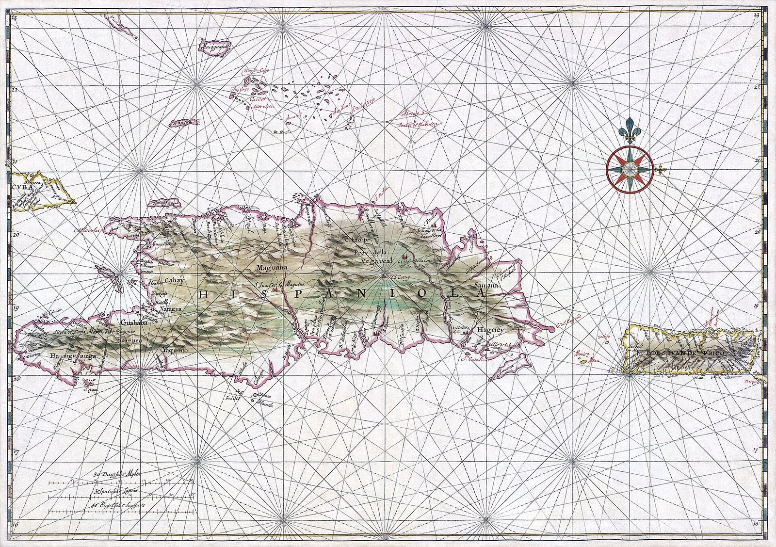
Hispaniola lies in the Caribbean, within the Greater Antilles. Cuba is to its west, and Puerto Rico is to its east. At approximately 76,192 square kilometres, it is the Caribbean’s second-largest island after Cuba.
On a map of Hispaniola, Haiti occupies the western part. The Dominican Republic occupies the eastern part. Hispaniola is the name of their shared island; each country has its own name and independent statehood.
That distinction has an everyday use. If you are reading a map or choosing a language for a conversation, the island’s name alone does not tell you which country or language is involved. Spanish is spoken in the Dominican Republic. French and Haitian Creole are spoken in Haiti.
What does Hispaniola mean?
Hispaniola is a Latinized form of the Spanish name Española. According to Pedro Mártir de Anglería’s explanation, the name expresses a diminutive form of Spain. Its origin therefore belongs to the island’s Spanish colonial history.
The name does not describe an island that began with European arrival. When Christopher Columbus reached Hispaniola in 1492, Indigenous communities already lived there. They included the Taíno, Ciguayo and Macorix.
Is Hispaniola where Columbus landed?
Yes. Columbus reached Hispaniola in 1492 and advanced Spanish colonization during his second voyage in 1493. His arrival provides an early date in the colonial story, but it does not explain the later French-Spanish division by itself.
Spanish settlement also produced Santo Domingo on the island’s southern coast. UNESCO dates the founding of its colonial city to 1498. This places the city’s beginnings well before the treaties that formally divided French and Spanish possessions.
Santo Domingo and Saint-Domingue are names you need to keep separate. Santo Domingo was the city on the southern coast. Saint-Domingue became the French colony in western Hispaniola, where the Haitian Revolution began.
How did France and Spain divide Hispaniola?
During the seventeenth century, French buccaneers established bases in western Hispaniola. Their presence helped prepare the ground for the French colony of Saint-Domingue. French colonial control thus developed in the west alongside Spain’s possessions in the east.
The decisive diplomatic recognition came in 1697. Through the Treaty of Ryswick, Spain recognized French sovereignty over approximately the western third of Hispaniola. This was a division between colonial powers, long before Haiti and the Dominican Republic existed as independent countries.
The Treaty of Aranjuez defined the boundary between the French and Spanish colonies in detail in 1777. These two treaties performed different tasks. Ryswick recognized French sovereignty in the west. Aranjuez specified the boundary between the colonies.
If you want to understand why the island contains two countries, begin with this colonial division. It established separate French and Spanish territories. Yet the later history included transfers of sovereignty and a period when Haiti governed both sides.
How did Saint-Domingue become Haiti?
By the 1760s, Saint-Domingue had become the most profitable colony in the Americas. Its sugar and coffee production depended on enslaved Africans. The colony’s wealth and the system of forced labour behind it belong to the same story.
On 22 August 1791, enslaved people launched a major uprising in northern Saint-Domingue. This marked the beginning of the Haitian Revolution. The western colony’s path toward independence grew from that struggle against slavery.
While the revolution continued, Spain surrendered its eastern possessions to France through the Treaty of Basel in 1795. The earlier arrangement of a French west and Spanish east therefore changed before Haitian independence. Colonial boundaries and political control did not remain fixed.
Napoleon’s forces re-established control in Saint-Domingue in 1802 and attempted to restore slavery. That effort triggered another wave of resistance. French forces were defeated in late 1803.
Jean-Jacques Dessalines declared Haiti independent on 1 January 1804. The former French colony had become an independent country. The eastern part of Hispaniola followed a different sequence of governments before the Dominican Republic emerged.
Why did the Dominican Republic separate from Haiti?
In 1809, the former Spanish colony in eastern Hispaniola left French rule and returned to Spanish sovereignty. This restored Spanish government in the east after Spain’s transfer of the territory to France in 1795.
José Núñez de Cáceres declared the east independent from Spain in 1821. Its separate administration lasted only a few months. In 1822, Haiti under Jean-Pierre Boyer brought the eastern territory under its government.
From 1822 to 1844, Haiti governed the whole island. This period lasted 22 years. It is essential to the answer: the two countries did not simply become independent on opposite sides of an untouched colonial boundary.
La Trinitaria, a secret society founded in 1838, worked toward independence. Those efforts culminated in the proclamation of the Dominican Republic on 27 February 1844. The new republic gained independence by separating from Haiti.
The Dominican Republic later returned to Spanish rule in 1861. Spanish government lasted until 1865. Its political history therefore included another period under Spain after the declaration of independence in 1844.
Timeline
- 1492: Columbus reached Hispaniola.
- 1498: Santo Domingo’s colonial city was founded, according to UNESCO’s dating.
- August 1604: The Spanish crown approved a plan to destroy northern and western coastal villages and forcibly relocate their inhabitants to the area around Santo Domingo.
- 1697: The Treaty of Ryswick recognized French sovereignty in the west.
- 1777: The Treaty of Aranjuez defined the French-Spanish colonial boundary.
- 1791: The uprising that began the Haitian Revolution started in Saint-Domingue.
- 1795: Spain ceded eastern Hispaniola to France.
- 1804: Dessalines declared Haiti independent.
- 1809: The east returned to Spanish rule.
- 1821: Núñez de Cáceres declared the east independent from Spain.
- 1822: Haiti under Boyer brought the whole island under one government.
- 1844: The Dominican Republic declared independence from Haiti.
- 1861–1865: The Dominican Republic was again under Spanish rule.
Details you won’t find in guidebooks
Santo Domingo’s layout has a specific administrative turning point. In 1502, Nicolás de Ovando moved its institutions to the western bank of the Ozama River. He applied a grid plan that became a model for later cities in the Americas.
Another turning point involved forced relocation. In August 1604, the Spanish crown approved a plan to destroy villages on Hispaniola’s northern and western coasts. Their inhabitants were to be moved forcibly to the area around Santo Domingo.
Saint-Domingue’s production figures show the scale of its plantation economy. Immediately before the Haitian Revolution, the colony produced approximately 40 percent of the sugar and 60 percent of the coffee imported into Europe. Enslaved labour sustained that production.
The colonial boundary also has a connection to the present map. Some sections of today’s border between Haiti and the Dominican Republic follow the line negotiated in 1777. You can therefore see part of the colonial division reflected in the boundary between the independent states.
Independence and foreign recognition were separate events for Haiti. Dessalines declared independence in 1804, but the United States formally recognized Haiti only on 12 July 1862. Those dates mark different stages in the country’s international history.
FAQ
Is Hispaniola a country?
Hispaniola is an island shared by two independent countries: Haiti in the west and the Dominican Republic in the east.
Where is Hispaniola located?
Hispaniola lies in the Caribbean’s Greater Antilles, east of Cuba and west of Puerto Rico. It is the Caribbean’s second-largest island after Cuba.
Is Hispaniola where Columbus landed?
Christopher Columbus reached Hispaniola in 1492. Taíno, Ciguayo and Macorix communities already lived on the island.
When did Haiti and the Dominican Republic become separate countries?
Haiti declared independence in 1804. After Haiti governed the whole island from 1822, the Dominican Republic declared independence from Haiti on 27 February 1844.
Sources
- Wikipedia — Hispaniola en.wikipedia.org
- Vikipedi — Hispanyola tr.wikipedia.org
- UNESCO — Colonial City of Santo Domingo whc.unesco.org
- Cambridge University Press — Repressing Smugglers: The Depopulations of Hispaniola, 1604–1606 cambridge.org
- Library of Congress — Map of the Dominican Republic loc.gov
- U.S. Department of State, Office of the Historian — The United States and the Haitian Revolution, 1791–1804 history.state.gov
- Slavery and Remembrance — Haiti (Saint-Domingue) slaveryandremembrance.org
- Florida International University — Haiti and the Dominican Republic, Eugenio Matibag islandluminous.fiu.edu
- U.S. Department of State, Office of the Historian — Haiti history.state.gov
Image: Hispaniola Vinckeboons4.jpg — Johannes Vingboons, Public domain