What does the name Siirt mean?
The history of Siirt and the origin of its name begin with several explanations. One connects the name to the Chaldean word Keert or Kaa’rat, meaning “city.” The Siirt Provincial Directorate of Culture and Tourism presents this as an origin theory. It also records explanations involving “three places” and the Turkish word sırt.
If you encounter different explanations of Siirt’s name, these alternatives help you understand why. The Chaldean connection is one proposal among several recorded by the same institution. Each explanation deserves to be presented as a theory, rather than turned into a settled translation of the modern name.
Historical spellings add firmer evidence to this discussion. The Provincial Directorate records the Syriac form Se’erd. It also lists Sert, Seerd, Sört and Sairt among forms used in the nineteenth century. Ottoman tax registers contain Siird and İs‘ird. These are documented forms of the city’s name, distinct from explanations of its meaning.
For you as a reader, that distinction matters. An Ottoman register spelling such as Siird records how the name appeared in a particular source. The proposed connection with Keert or Kaa’rat addresses a different question: where the name came from. The spelling evidence and the origin theories should therefore be read separately.
How far back does settlement around Siirt go?
Başur Höyük provides evidence for a much earlier past in the surrounding area. It lies west of Siirt, in the Bakır hamlet of Aktaş village. According to the excavation director’s assessment, settlement evidence there extends to the seventh millennium BCE. This date concerns the mound near Siirt.
The settlement area measures approximately 250 by 150 metres. Its accumulated cultural deposits rise about 15 metres. Those measurements describe both the site’s extent and the depth of material left by occupation. They give you a concrete sense of the archaeological setting behind the early dates.
The cemetery supplies another chronological marker. The Natural History Museum dates the examined burials at Başur Höyük to 3100–2800 BCE. These graves belong to a later period than the earliest settlement evidence reported at the mound. Keeping those dates separate helps preserve the sequence of occupation and burial.
Modern investigation also has its own history. The Turkish Wikipedia account links the 1963 surveys in Siirt with the Joint Project for Prehistoric Research in Southeastern Anatolia, conducted by Halet Çambel and R. J. Braidwood. The surveys form part of the story of how the region’s prehistoric remains were investigated.
How did Siirt pass between medieval and Ottoman rulers?
Siirt entered Islamic territory in 639 during the conquests of İyâz b. Ganm. Another change followed in 1085. Fahrüddevle İbn Cehîr took the city from the Marwanids and had the Friday sermon delivered in the name of the Great Seljuks. The account records both the takeover and its public expression.
In 1231, Mongol forces devastated Siirt while pursuing Celâleddin Hârizmşah. This destruction belongs between the Seljuk takeover of 1085 and the recorded enlargement of the Great Mosque in 1260. These dates place political violence and building activity within the same medieval sequence.
Siirt became part of Ottoman territory in the process following Yavuz Sultan Selim’s victory at Çaldıran in 1514. Later Ottoman records preserve the city’s name as Siird or İs‘ird. The political chronology and the written forms of the name therefore meet in the documentary history of Ottoman Siirt.
An administrative change came in 1884, when Siirt was transferred from Diyarbekir province to Bitlis province. The 1927 census recorded 14,830 people in the city centre. That figure refers specifically to the urban centre, a useful distinction when you compare the city with the wider province.
What do the dates of Siirt’s Great Mosque tell you?
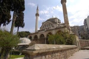
The Great Mosque, or Ulu Cami, requires careful reading of its dates. The Provincial Directorate’s detailed building account identifies 1129 as a repair by Mugīsüddin Mahmûd. It should therefore be described as a documented repair date. Treating it as the mosque’s construction date would change what that account actually says.
In 1260, Mücâhid İshak repaired and enlarged the mosque. A madrasa was added beside it, turning the site into a religious complex. The mosque’s history thus includes more than one building campaign. The 1129 repair and the 1260 expansion mark separate interventions.
The building also has a striking relationship with the surrounding ground. It stands an average of 3.5 metres below the neighbouring surface level. A broad staircase on the north leads down into its courtyard. If you visit, that descent gives you a direct physical detail to connect with the mosque’s architectural history.
The minaret underwent another major intervention in 1974–1975. It had been leaning eastward and was dismantled and rebuilt. Its history therefore includes modern reconstruction alongside the medieval repairs recorded for the mosque.
What is the significance of Tillo’s tomb and light mechanism?
In Tillo, İbrahim Hakkı commissioned the tomb of his teacher İsmail Fakirullah in the eighteenth century, after the teacher’s death. The monument brings a named relationship into Siirt’s wider heritage: a pupil arranging a tomb for his teacher.
The tomb and its light mechanism were submitted to the UNESCO World Heritage Tentative List on 13 April 2015. This is the precise designation attached to that submission. The UNESCO text also states that an incorrect restoration in 1963 caused the tomb to lose part of its authenticity.
The submission describes a timed effect inside the monument. On the mornings of 21 March and 23 September, the mechanism directs sunlight toward the head of İsmail Fakirullah’s cenotaph for approximately six minutes. Both the calendar dates and the brief duration are part of the recorded arrangement.
Where does the surrounding landscape enter Siirt’s history?
Botan Valley National Park extends across Siirt’s central district, Tillo and Eruh. It received national park status in 2019. The Cultural Portal lists historical remains within this landscape, including churches in Yerlibahçe, Kayaboğaz, Kalender and Koçlu villages. It also names Mor Yakup Monastery in the Deyr area.
Taşbaşı Cave adds evidence of shelter to this landscape. About four kilometres southeast of Siirt, it overlooks the Botan stream from roughly 350 metres above it. The cave was used for habitation. Its position and recorded use connect the valley with the practical need for somewhere to live.
Timeline
- Seventh millennium BCE: Settlement evidence at Başur Höyük extends to this period.
- 3100–2800 BCE: The examined Başur Höyük cemetery burials date to this interval.
- 639: Siirt entered Islamic territory.
- 1085: Fahrüddevle İbn Cehîr took Siirt for the Great Seljuks.
- 1129: The Great Mosque underwent a recorded repair.
- 1231: Mongol forces devastated Siirt.
- 1260: The Great Mosque was repaired and enlarged, with a madrasa added.
- After 1514: Siirt became part of Ottoman territory.
- Eighteenth century: İbrahim Hakkı commissioned İsmail Fakirullah’s tomb in Tillo.
- 1884: Siirt was attached to Bitlis province.
- 1927: The city centre’s population was recorded as 14,830.
- 1963: Prehistoric surveys were conducted in Siirt.
- 1974–1975: The Great Mosque’s leaning minaret was dismantled and rebuilt.
- 2015: The Tillo tomb and light mechanism were submitted to UNESCO’s Tentative List.
- 2019: Botan Valley became a national park.
Details you won’t find in guidebooks
Traditional Siirt houses offer an everyday connection with the past. Built with a gypsum-based material called cas, they appear flat-roofed from outside and domed inside. Think of looking at your own home from the street, then looking up at its ceiling. In these houses, the exterior and interior reveal different roof forms.
The Great Mosque’s walnut minbar preserves unusually specific information. Displayed in the Ankara Ethnography Museum, it bears the date 1214–1215. It also carries the names of eight artists and the trustee. The object records named contributors alongside its date.
At Başur Höyük, the remains examined in three graves included at least eleven individuals. Their ages ranged from eleven years to young adulthood. This detail gives the cemetery chronology a human scale, while keeping the evidence tied to the particular graves studied.
At Taşbaşı, a small window between two caves allows passage from one to the other internally. Alongside the recorded use of the caves for habitation, this opening supplies a concrete detail of how the spaces connect.
FAQ
What does the name Siirt mean?
One theory connects Siirt with the Chaldean Keert or Kaa’rat, meaning “city.” The Provincial Directorate of Culture and Tourism also records explanations involving “three places” and the Turkish word sırt.
How old is the archaeological evidence around Siirt?
Başur Höyük, west of Siirt, contains settlement evidence extending to the seventh millennium BCE, according to the excavation director’s assessment. The burials examined at its cemetery date to 3100–2800 BCE.
Was Siirt’s Great Mosque built in 1129?
The Provincial Directorate of Culture and Tourism’s detailed account identifies 1129 as a repair by Mugīsüddin Mahmûd. It records a further repair and enlargement by Mücâhid İshak in 1260.
What happens at İsmail Fakirullah’s tomb in Tillo?
According to the UNESCO submission, a mechanism directs sunlight toward the head of İsmail Fakirullah’s cenotaph for about six minutes on the mornings of 21 March and 23 September.
Sources
- Siirt Provincial Directorate of Culture and Tourism — Tarihçe siirt.ktb.gov.tr
- TDV İslâm Ansiklopedisi — Siirt islamansiklopedisi.org.tr
- Turkish Wikipedia — Siirt tr.wikipedia.org
- Ege University — EÜ Kazılarıyla Geçmişin İzinde egekitap.ege.edu.tr
- Natural History Museum — New evidence of ancient child sacrifice found in Turkey nhm.ac.uk
- Siirt Provincial Directorate of Culture and Tourism — Tarihi Ulu Camii siirt.ktb.gov.tr
- UNESCO World Heritage Centre — Ismail Fakirullah Tomb and its Light Refraction Mechanism whc.unesco.org
- Cultural Portal — Botan Vadisi Milli Parkı kulturportali.gov.tr
- Siirt Provincial Directorate of Culture and Tourism — TaşBaşı DelikliTaş siirt.ktb.gov.tr
Image: Siirt Ulu Camii 1543.jpg — Dosseman, CC BY-SA 4.0