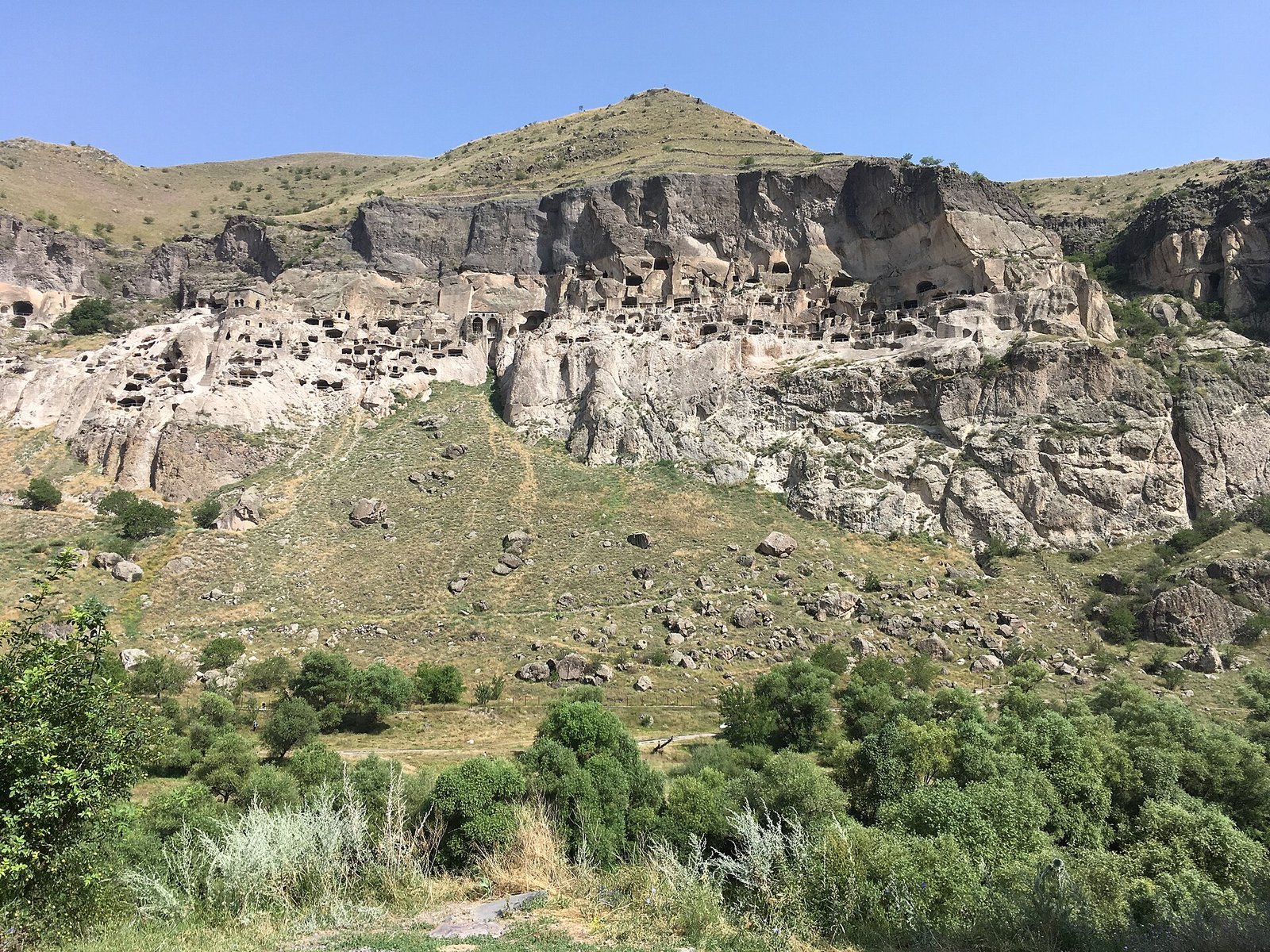
Vardzia was built by carving dwellings, a church and connecting tunnels into volcanic rock on Mount Erusheti in southern Georgia. Its main construction took place in the second half of the twelfth century, beginning under Giorgi III and continuing under his daughter, Queen Tamar. Later building phases added housing, defenses, water supply and irrigation networks.
How did those excavated rooms become a functioning monastery? The answer lies in the connections between them: tunnels joined different levels, a water line supplied the settlement, and cellars stored wine. If you follow these features alongside the royal building phases, Vardzia becomes easier to understand as a place where people lived and worked.
Where is Vardzia, Georgia’s cave city?
Vardzia stands in the Aspindza district of Samtskhe-Javakheti, in southern Georgia. Its rooms were cut into the slope of Mount Erusheti on the left bank of the Kura River, also called the Mtkvari. Aspindza is about 30 kilometres away.
The main settlement occupies a layer of tuffaceous breccia at approximately 1,300 metres above sea level. Across the wider complex, excavated spaces extend through different layers of volcanic tuff over several hectares. The rock itself therefore forms the setting and much of the structure you see.
The caves stretch for about 500 metres along the rock face. In some parts, the complex reaches 19 levels. Those figures describe a settlement spread both across the mountainside and through its height, with tunnels connecting its different levels.
How was Vardzia built under Giorgi III and Tamar?
The first cave dwellings and the planning of the settlement date to Giorgi III’s reign, from 1156 to 1184. He initiated the project that Tamar subsequently continued. Vardzia’s construction therefore crossed the transition between a father’s reign and his daughter’s rule.
Excavation created usable rooms inside the volcanic layers. Connecting tunnels linked levels within the settlement, while the main church divided the cave complex into eastern and western sections. Its layout combined individual spaces with routes between them.
The Church of the Dormition was carved and decorated between Giorgi III’s death in 1184 and Tamar’s marriage in 1186. This short building phase places the church near the beginning of Tamar’s continuation of the project. It also provides a dated point within the wider construction history.
From 1186 until the Battle of Basian around 1203, construction expanded the settlement’s practical systems. New dwellings accompanied defensive arrangements, water supply and irrigation infrastructure. These works show that building Vardzia involved much more than opening additional chambers in the cliff.
You can connect that infrastructure with an everyday concern: having water available where you live. Vardzia received its supply through a line approximately 3.5 kilometres long from Zeda Vardzia village. The distance makes water provision a substantial part of the settlement’s construction story.
What made Vardzia a cave monastery?
The Church of the Dormition occupies a central position in the main complex, separating its eastern and western sections. It was cut into the rock, with stone reinforcing its walls. Excavation and masonry therefore worked together within the same building.
The church measures approximately 8.2 by 14.5 metres and stands about 9.2 metres high. These dimensions help explain its place within the settlement. Among the many excavated rooms, it provided a religious space with considerable internal height.
The eastern section contains 79 cave dwellings distributed across eight levels, with 242 rooms in total. Those counts distinguish a dwelling from an individual room. They also give a more detailed picture of the settlement than the general description of a mountainside full of caves.
Religious life existed alongside food preparation, storage and craft work. Between the bell tower and the main church, the western section includes a refectory with a bread oven and a forge. These working spaces belong to the same complex as the painted church.
Details you won’t find in guidebooks
The eastern section contains 25 wine cellars and 185 wine jars sunk into the ground. These installations show the place of viticulture in the monastery’s economy. They also make storage a visible part of Vardzia’s architecture, alongside its dwellings and religious rooms.
The bread oven in the western refectory brings the monastery close to an ordinary household routine. Bread preparation had a designated place within the complex. The forge adds another kind of work to this picture of daily life inside the excavated settlement.
Tamar’s portrait in the church supplies a small but useful dating clue. It lacks the ribbon associated with married women. That detail helps place the painting before her marriage in 1186, connecting a feature of dress with the chronology of the church’s decoration.
The wall paintings also have a technical detail worth looking for. The ICOMOS assessment describes them as secco paintings, applied to a dry surface. The painted surface thus adds another stage to the work of cutting the church and reinforcing its walls.
What can Vardzia photos show you about its construction?
The approximately 500-metre spread of caves gives photographs a broad architectural subject. Yet the layout has a clear internal division: the Church of the Dormition separates the eastern and western parts. When you look at Vardzia photos, that church offers a reference point for understanding the arrangement.
The different level counts also deserve attention. Parts of the whole complex reach 19 levels, while the eastern group of 79 dwellings occupies eight. These measurements refer to different portions of Vardzia and help explain the variation across its rock face.
Tunnels provide another part of the layout beyond the visible openings. They connect the settlement’s levels. Understanding those links helps you read the caves as connected spaces within a larger complex.
How did earthquakes and warfare change Vardzia?
A severe earthquake struck Vardzia in 1283. The complex suffered heavy damage, and subsequent repairs restored it only partly. The earthquake therefore marks a major break between the medieval building phases and the settlement’s later condition.
Military violence brought further destruction in the sixteenth century. The Safavid historian Hasan Beg Rumlu records that the forces of Shah Tahmasp I sacked Vardzia in 1551. His account identifies a specific attack within the monastery’s later history.
In 1578, the Ottomans arrived in the region. The monks subsequently left Vardzia, and the monastery was abandoned. For readers interested in Ottoman history, this date connects the cave settlement with the region’s wider military changes.
Timeline
- 1156–1184: During Giorgi III’s reign, the settlement was planned and its first cave dwellings were carved.
- 1184–1186: The Church of the Dormition was excavated and decorated.
- 1186–around 1203: Construction expanded housing, defenses, water supply and irrigation networks.
- 1283: An earthquake severely damaged the complex. Partial repairs followed.
- 1551: According to Hasan Beg Rumlu, Shah Tahmasp I’s forces sacked Vardzia.
- 1578: Following the Ottoman arrival in the region, the monks left the monastery.
- 24 October 2007: The Vardzia-Khertvisi area was submitted to UNESCO’s Tentative List.
- 2014–2015: A monitoring project began, and its main components were installed by the end of 2015.
Why does Vardzia’s weather matter to its preservation?
Rainwater runoff, groundwater seepage, temperature changes and rock fractures contribute to deterioration at Vardzia. The volcanic layers that contain the settlement are therefore central to its preservation as well as its construction. Water remains part of the site’s story, now as a source of damage alongside its earlier role as a supply.
A monitoring project launched in 2014 addresses these environmental and geological conditions. Its main components were installed by the end of 2015. The system was designed to monitor meteorological conditions and temperature and humidity inside the caves.
How far is Vardzia from Tbilisi, and what does UNESCO recognize?
Georgia’s National Tourism Administration places Vardzia approximately 300 kilometres from Tbilisi. Its local setting remains the Mtkvari valley, about 30 kilometres from Aspindza. These distances locate the monastery within southern Georgia and in relation to the capital.
The area submitted to UNESCO extends beyond the main caves. Vardzia-Khertvisi covers an approximately 18-kilometre cultural landscape in the upper Mtkvari basin, stretching from Khertvisi to Vardzia. It was submitted to the Tentative List on 24 October 2007; this is distinct from inscription on the World Heritage List.
FAQ
How was Vardzia built?
Vardzia was created by carving dwellings, a church and connecting tunnels into volcanic rock on Mount Erusheti. Giorgi III began the settlement, and Queen Tamar continued its construction, including expanded housing, defenses and water infrastructure.
Where is Vardzia in Georgia?
Vardzia is in the Aspindza district of Samtskhe-Javakheti in southern Georgia. It occupies the left bank of the Mtkvari River, about 30 kilometres from Aspindza and approximately 300 kilometres from Tbilisi.
What damaged Vardzia?
An earthquake severely damaged Vardzia in 1283, and repairs restored only part of the complex. Hasan Beg Rumlu also records a sack by Shah Tahmasp I’s forces in 1551.
Is Vardzia a UNESCO World Heritage Site?
The Vardzia-Khertvisi area was submitted to UNESCO’s Tentative List on 24 October 2007. That submission does not mean it has been inscribed on the World Heritage List.
Sources
- UNESCO World Heritage Centre — Vardzia-Khertvisi whc.unesco.org
- ICOMOS — Vardzia-Khertvisi Assessment whc.unesco.org
- Ilia State University — Vardzia Complex Monitoring: Geology vardzia.iliauni.edu.ge
- Georgia Travel — Vardzia georgia.travel
- English Wikipedia — Vardzia en.wikipedia.org
Image: Vardzia 1 July 2018.jpg — Shomroni, CC BY-SA 4.0