Where is Port Royal in Jamaica?
Port Royal lies in southeastern Jamaica, at the tip of the Palisadoes sand spit. It stands at the entrance to Kingston Harbour. On 7 June 1692, an earthquake caused about two-thirds of the settlement to sink into the sea. A tsunami followed and increased the destruction.
If you are locating Port Royal on a map, start with Kingston Harbour and follow the Palisadoes to its tip. That position explains much of the town’s history. Its sheltered, deep-water harbour supported trade, while its location made defending the harbour entrance a priority for the English.
The sand spit had a history before English fortifications appeared. Taíno people used it as a fishing camp before Europeans arrived. The later port grew on ground that had already supported fishing, long before it became associated with privateers and sunken streets.
How did Port Royal become a pirate city?
After taking Jamaica in 1655, the English began fortifying Port Royal’s strategic position. They initially called the settlement Cagway. It later became Port Royal. For much of the period between 1655 and 1692, it served as Jamaica’s practical centre, although Spanish Town remained the official capital.
Port Royal’s connection with piracy included privateering authorised by Jamaica’s governor. The governor issued commissions that allowed captains based there to attack Spanish ships and settlements. These commissions explain how raiding could operate with official backing from the same island whose harbour sheltered the captains.
Henry Morgan used Port Royal as a base and died there in 1688. His connection places a named privateer within the town’s history. Yet its wealth also depended on trade through the harbour and the buying and selling of enslaved Africans. Slavery belongs at the centre of any account of its prosperity.
Six defensive forts protected the seventeenth-century settlement described by UNESCO. One was built in 1656 as Fort Cromwell. It was renamed Fort Charles in 1662 in honour of King Charles II. Its changing name records part of the town’s English history before the earthquake.
How did the 1692 earthquake make Port Royal sink?
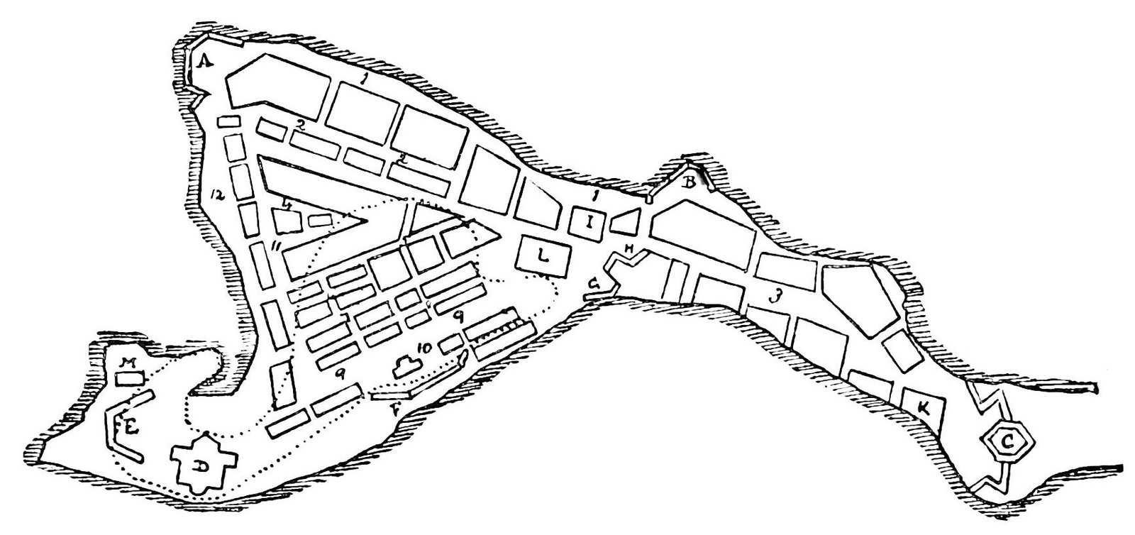
The earthquake struck on 7 June 1692. Around 33 acres, or approximately 13.4 hectares, sank into the sea. That area represented about 66 percent of Port Royal. The familiar description of two-thirds of the town sinking is therefore an approximation of a measured area.
Liquefaction was one of the main mechanisms behind the collapse. Earthquake vibrations caused the sandy sediment beneath Port Royal to lose strength and behave like a fluid mass. The failure extended beneath the buildings: the ground supporting the settlement could no longer hold it securely.
When you picture Port Royal sinking, keep that loss of ground strength in view. The town stood on a sand spit, and earthquake shaking transformed its supporting sediment. The geological explanation connects the settlement’s location directly with the way so much of it entered the sea.
A tsunami followed the earthquake. It swept ships along Port Royal’s waterfront and increased the damage to structures that were still standing. Ground failure and the movement of water were therefore separate parts of the same disaster. Surviving the first collapse did not mean a building escaped further destruction.
How many people died, and how was the disaster understood?
The Institute of Nautical Archaeology states that about 2,000 people died immediately in the earthquake. More people died from injuries and disease during the following days. The immediate estimate should therefore be read as one part of the disaster’s human cost.
A religious interpretation also followed. The Jamaican Assembly’s provision for an annual fast treated the catastrophe as divine punishment for sins. That response records how the disaster was understood in moral terms. The physical explanation for the sinking centres on earthquake-induced liquefaction of the sandy ground.
What happened to Port Royal after the earthquake?
Fort Charles was the only Port Royal fort to survive the 1692 earthquake. Colonel Christian Lilly, an engineer, rebuilt it in 1699. Its survival shows that the destruction, although extensive, did not erase every defensive structure within the settlement.
Kingston grew across the harbour and took over Port Royal’s commercial role after the disaster. Port Royal itself was rebuilt largely with wooden structures. A major fire destroyed much of that rebuilt town in 1703, bringing another severe disruption after the earthquake.
Port Royal continued to matter as a British naval station during the eighteenth century. Another major earthquake damaged it in 1907. Its history therefore extends beyond the famous sinking: the surviving settlement experienced rebuilding, naval use and further destruction.
Timeline
- 1655: The English took Jamaica and began fortifying Port Royal.
- 1656: Fort Cromwell, later called Fort Charles, was built.
- 1688: Henry Morgan died in Port Royal.
- 7 June 1692: An earthquake, liquefaction and tsunami devastated the town. About two-thirds sank.
- 1699: Christian Lilly rebuilt Fort Charles.
- 1703: A major fire damaged the rebuilt settlement.
- 1907: Another major earthquake struck Port Royal.
- 1959: A pocket watch stopped at 11:43 was recovered.
- 1981: Joint underwater investigations by INA, Texas A&M University and the Jamaica National Heritage Trust began.
- 2025: UNESCO inscribed the seventeenth-century archaeological ensemble on the World Heritage List.
- 2026: Research identifying a letter-sealing device was published.
Details you won’t find in guidebooks
Some brick walls collapsed inward into rooms during the disaster. Their fall covered objects and helped preserve them archaeologically. A destructive event thus created conditions that protected parts of the town’s contents beneath fallen building material.
The underwater environment also mattered. Low oxygen levels helped preserve many organic objects that could otherwise have decayed. The archaeological record includes material whose survival depended on conditions beneath the water, as well as objects covered by collapsed walls.
A brass pocket watch recovered in 1959 had been made in Amsterdam in 1686. It had stopped at 11:43. That reading has been associated with the time of the earthquake. The watch offers a striking connection with the disaster, although the association should not be treated as an independently certain timestamp.
The five buildings examined in the Port Royal excavations included homes, a pipe shop, a tavern and a shoemaker’s premises. If you connect history with everyday errands, the shoemaker’s premises offer a familiar link to daily life alongside ships, forts and privateering.
An iron object found in 1989 initially resisted identification. Research published in 2026 identified it as a tabletop device for melting wax to seal letters. Its function adds correspondence to the activities represented by objects recovered from the submerged town.
The remains of HMS Swan entered rooms 4A and 4B of Building 4 after the ship was swept along by the harbour wave following the earthquake. This places evidence of the moving ship inside specific excavated rooms. It gives the tsunami’s destructive movement a precise archaeological setting.
What does underwater archaeology reveal about Port Royal?
INA, Texas A&M University and the Jamaica National Heritage Trust began their joint underwater work in the submerged commercial centre in 1981. The buildings and objects they investigated allow Port Royal to be studied through its domestic and commercial spaces, as well as its maritime history.
The identified homes and businesses give those spaces concrete functions. A tavern, pipe shop and shoemaker’s premises show different activities within the investigated buildings. Preserved organic material and the letter-sealing device add further evidence of the objects people handled in the town.
Why is Port Royal a UNESCO World Heritage Site?
Port Royal’s seventeenth-century remains on land and underwater entered the UNESCO World Heritage List as cultural heritage in 2025. The inscription brings both parts of the archaeological ensemble together. The surviving land remains and the submerged settlement belong to the same historical place.
The UNESCO property covers 27 hectares, with a surrounding buffer zone of 292.27 hectares. These figures describe the heritage property’s boundaries and its buffer. The 13.4-hectare figure describes the approximate area that sank during the 1692 earthquake.
FAQ
Where is Port Royal?
Port Royal is at the tip of the Palisadoes sand spit, at the entrance to Kingston Harbour in southeastern Jamaica.
How did Port Royal sink in 1692?
Earthquake shaking caused liquefaction in its sandy ground. About two-thirds of the settlement sank, and a following tsunami increased the destruction.
How many people died in the Port Royal earthquake?
The Institute of Nautical Archaeology estimates that about 2,000 people died immediately. Injuries and disease caused further deaths in the following days.
Did all of Port Royal disappear?
About 66 percent of the settlement sank. Fort Charles survived, and the town continued after the disaster, although a fire in 1703 caused further destruction.
Sources
- Turkish Wikipedia — Port Royal tr.wikipedia.org
- Jamaica National Heritage Trust — Port Royal jnht.com
- English Wikipedia — Port Royal en.wikipedia.org
- UNESCO — The Archaeological Ensemble of 17th Century Port Royal whc.unesco.org
- Jamaica National Heritage Trust — Remembrance of the Great Earthquake jnht.com
- Institute of Nautical Archaeology — Port Royal Harbor Excavation nauticalarch.org
- National Geographic — How the ‘wickedest city on Earth’ was sunk by an earthquake nationalgeographic.com
- Historical Archaeology — A Sealed Fate link.springer.com
Image: PSM V40 D802 Port royal before the 1692 earthquake and the dotted area after.jpg — Unknown authorUnknown author, Public domain