What was the Kon-Tiki expedition?
On 28 April 1947, Thor Heyerdahl and five companions left Callao, Peru, aboard Kon-Tiki. Their destination was Polynesia. Their vessel was a raft built around nine large balsa logs lashed together with ropes. Over 101 days, they travelled approximately 4,300 miles, or 6,900 kilometres, across the Pacific.
The crossing ended on 7 August 1947, when Kon-Tiki struck the coral reef at Raroia in the Tuamotu Islands. The raft had carried its crew from South America to Polynesia. Yet reaching Polynesia and explaining its prehistoric settlement were separate achievements. The expedition demonstrated a possible journey. It did not prove who had made that journey in the past.
If you follow the voyage from Callao to Raroia, keep that distinction in view. Heyerdahl relied on winds and currents to carry a balsa raft across the ocean. His larger argument concerned whether Indigenous South Americans could have contributed to the settlement of Polynesia.
Why did Thor Heyerdahl sail toward Polynesia?
Heyerdahl began developing his theory on Fatu Hiva in 1937. He proposed that Indigenous people from South America might have taken part in populating Polynesia. The 1947 expedition tested whether a raft could make the crossing that his argument required.
The raft’s name expressed that connection. Kon-Tiki came from the legendary Kon-Tiki Viracocha, whom Heyerdahl associated with his theory. In the account linked to that figure, Kon-Tiki Viracocha travelled west from Peru on a balsa raft. The expedition therefore carried a name tied directly to the route Heyerdahl wanted to test.
Heyerdahl expected easterly winds and the Humboldt Current to help carry Kon-Tiki toward Polynesia. That expectation shaped the voyage. The crew would cross aboard a raft whose movement depended heavily on the ocean and atmosphere, rather than on their ability to choose a precise course.
How was the Kon-Tiki raft built and handled?
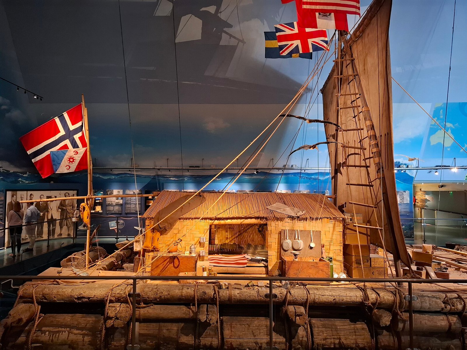
Nine large balsa logs formed Kon-Tiki’s main body. The principal logs could reach approximately 14 metres in length and 60 centimetres in diameter. Ropes held them together. Above this wooden platform stood an A-shaped mast approximately 8.8 metres high and a shelter made from bamboo.
The raft also had steering boards called guaras. During the expedition, these remained largely fixed. Winds and currents therefore determined much of the route. When you picture Kon-Tiki crossing the Pacific, the relationship between its construction and its movement matters: the crew travelled on a platform that largely followed the forces carrying it west.
The departure included assistance from the Peruvian navy. Its tug Guardian Rios towed Kon-Tiki approximately 80 kilometres at the start, taking it away from coastal traffic. The ocean crossing thus began with a tow before the raft continued under the influence of winds and currents.
Six men made up the crew: Thor Heyerdahl, Herman Watzinger, Erik Hesselberg, Knut Haugland, Torstein Raaby and Bengt Danielsson. Hesselberg served as the expedition’s navigator. He also had artistic training, which found a visible place on the raft’s sail.
How did the voyage reach Raroia?
The crew first sighted land on 30 July 1947, at Puka-Puka atoll. That sighting came before the expedition’s eventual landfall at Raroia. Seeing an island did not mean the raft could safely reach its shore, a problem that became clearer at the next recorded stop.
Kon-Tiki reached Angatau on 4 August. The crew made contact with local people, but they could not land safely. Angatau therefore marked contact without a successful landing. For a raft guided mainly by wind and currents, arriving near land and getting ashore were different practical problems.
On 7 August, Kon-Tiki struck Raroia’s coral reef. The impact ended the 101-day crossing. Raroia villagers later collected the crew in canoes. The French schooner Tamara then transported the men to Tahiti, towing the raft behind it.
The sequence matters when you trace the route: Puka-Puka was the first land sighted, Angatau brought contact without a safe landing, and Raroia was where the crossing ended. Tahiti followed as the destination reached aboard Tamara, with Kon-Tiki under tow.
Details you won’t find in guidebooks
Kon-Tiki carried 1,040 litres of drinking water in 56 containers. Sealed bamboo stems also provided water storage. The familiar task of packing water for a day out offers an everyday connection: aboard this raft, supplying drinking water meant distributing it across dozens of containers for an ocean crossing.
The six men were accompanied by a parrot when they left Callao. That small detail belongs alongside the expedition’s larger measurements. The departure involved nine main logs, six crew members, drinking-water containers and a bird aboard the same raft.
Erik Hesselberg painted the large mask on Kon-Tiki’s sail. His contribution joined his artistic training to his role as navigator. The sail’s image was therefore the work of someone who also helped the crew follow their position during the crossing.
On 5 August 1947, Knut Haugland established radio contact with Oslo from the raft. The connection spanned approximately 16,000 kilometres. It took place after Kon-Tiki reached Angatau and before the crossing ended at Raroia.
Moving the raft in Oslo presented another practical problem. Seawater had made it heavier, bringing its weight to 20 tonnes. A floating crane named Goliath was hired to unload it from the ship. The raft’s later museum life began with the physical challenge of lifting waterlogged timber.
Did Kon-Tiki prove prehistoric contact?
The Kon-Tiki Museum distinguishes the successful crossing from Heyerdahl’s settlement theory. Its assessment is that the voyage showed travel by balsa raft was possible. It did not prove his explanation of prehistoric settlement. A completed route could establish feasibility without establishing a past migration.
A genetic study by Ioannidis and colleagues, published in Nature in 2020, examined 807 people. It concluded that contact between Polynesians and Native Americans occurred around 1200. This finding supported prehistoric contact, but it did not turn the 1947 raft voyage into proof of Heyerdahl’s proposed settlement route.
Stanford researchers offered an alternative explanation for the genetic findings. They considered it more likely that Polynesians reached the coast of present-day Colombia than that Native Americans drifted to Polynesia. The direction of travel therefore remained central to interpreting the evidence.
For you, the useful distinction is between three claims: a raft could cross the Pacific; prehistoric populations had contact; and people travelled in a particular direction. Kon-Tiki demonstrated the first. The 2020 study supported the second. The Stanford interpretation favoured Polynesians reaching the Americas.
Kon-Tiki book: what did Heyerdahl publish?
Heyerdahl’s account, The Kon-Tiki Expedition, first appeared in 1948. It was translated into more than 70 languages. The book followed the completed crossing and carried his account of the raft voyage to readers beyond the expedition itself.
The black-and-white documentary Kon-Tiki, released in 1950, won the Academy Award for Best Documentary Feature in 1951.
Kon-Tiki Museum: where is the raft, and what survives?
The original raft used in 1947 is displayed at the Kon-Tiki Museum in Oslo. If you want to connect the voyage’s measurements with its surviving vessel, this is where the raft itself can be seen. Its first temporary exhibition building opened to visitors on 15 May 1950.
The Thor Heyerdahl Archive also preserves expedition photographs and documents. It entered UNESCO’s Memory of the World register in 2011. For readers interested in real Kon-Tiki photographs, the archive connects the crossing with its surviving visual and documentary record.
The raft and archive preserve different parts of the same expedition. The museum holds the vessel that crossed from Peru to Polynesia. The archive includes photographs and documents associated with Heyerdahl’s work, including the expedition record.
Timeline
- 1937: Heyerdahl began developing his theory of prehistoric links between South America and Polynesia on Fatu Hiva.
- 28 April 1947: Kon-Tiki departed Callao with six crew members.
- 30 July 1947: The crew sighted Puka-Puka atoll.
- 4 August 1947: The raft reached Angatau, but a safe landing was not possible.
- 5 August 1947: Knut Haugland established radio contact with Oslo.
- 7 August 1947: The 101-day crossing ended on Raroia’s reef.
- 1948: Heyerdahl’s expedition book was published.
- 15 May 1950: The raft’s first temporary exhibition building opened.
- 2011: The Thor Heyerdahl Archive entered UNESCO’s Memory of the World register.
- 2020: Nature published the genetic study supporting prehistoric contact between Polynesians and Native Americans.
FAQ
How long did the Kon-Tiki expedition take?
The crossing took 101 days and covered approximately 4,300 miles, or 6,900 kilometres, from Peru to Polynesia.
Where is the original Kon-Tiki raft?
The original raft used in the 1947 expedition is displayed at the Kon-Tiki Museum in Oslo.
Did Kon-Tiki prove Heyerdahl’s settlement theory?
No. It demonstrated that a balsa raft could cross from South America to Polynesia, but it did not establish that prehistoric settlers made that journey.
Where can you find information about real Kon-Tiki photographs?
The Thor Heyerdahl Archive includes expedition photographs and documents. It entered UNESCO’s Memory of the World register in 2011.
Sources
- Kon-Tiki Museum — Kon-Tiki, 1947 kon-tiki.no
- Kon-Tiki Museum — How Kon-Tiki launched a worldwide age of experimental seafaring kon-tiki.no
- Wikipedia — Kon-Tiki expedition en.wikipedia.org
- Vikipedi — Kon-Tiki tr.wikipedia.org
- Nature — Native American gene flow into Polynesia predating Easter Island settlement doi.org
- Stanford Medicine — Polynesians, Native Americans made contact before European arrival, genetic study finds med.stanford.edu
- Kon-Tiki Museum — Visit The Kon-Tiki Museum kon-tiki.no
- Kon-Tiki Museum — The Kon-Tiki Museum 75 years kon-tiki.no
- Kon-Tiki Museum — Thor Heyerdahl’s archive kon-tiki.no
Image: Kon-Tiki raft, side view.jpg — Wikipek, CC0