Kilis is a small border city with a long memory. Its story starts in a mound of earth outside town. It passes through a medieval castle, an Ottoman family estate and two foreign occupations. It ends with a provincial flag in 1995. If you are planning a trip, this guide gives you the order of events and the places where you can still see them.
Where Kilis sits
The city centre lies close to the Türkiye–Syria border, at about 36.72° north and 37.12° east. That position explains a lot. Roads, armies and traders have crossed this land for thousands of years. The border itself is young. A protocol attached to the Turkish–French Friendship and Good Neighbourliness Convention of 30 May 1926 moved the line south of Kilis by 4–5 kilometres.
Kilis history: the long view
The oldest layers are not in the city. They are at Oylum Höyük, a mound near Kilis. Its settlement layers reach back to the Late Chalcolithic Age. The site sits where routes meet: those linking the Euphrates Valley with the Amik Plain, and northern Syria with the Anatolian Plateau. The mound has two rises, 22 and 37 metres high, joined by a neck.
Excavation here began in 1987 as a rescue dig. One of its main aims, according to Engin Özgen’s report, was to stop villagers from damaging the settlement.
The finds include something you can taste today. Archaeologists recovered charred olive stones about 4,500 years old. They also found vessels that excavation director Atilla Engin describes as olive oil storage jars. So when you buy a bottle of local oil in the Kilis market, you are tied to a habit that is very old.
Where does the name Kilis come from?
There is no single agreed answer. Three explanations compete.
The Cyrrhus theory. One view links the name to ancient Cyrrhus, read as Kiris. The Kilis provincial directorate of the Ministry of Environment, Urbanisation and Climate Change presents the change as a result of Turkmen pronunciation.
The objection. Historian Hasan Yenidoğan spoke on this at Kilis 7 Aralık University. He said that claims tying the name to Kiliza, Kyrrhos or Kenîset have no historical basis.
The Assyrian Kilizi. Some writers say the Kilizi in Assyrian documents is today’s Kilis. The TDV Encyclopedia of Islam does not accept this as certain. It lists three possible places for the old settlement: Tarzimehan, İlizi Bahçesi and Oylumhöyük.
What we can say with confidence is how the name was written in documents. The geographer Yâkût al-Hamawî, in his Muʿcemü’l-büldân, calls the place Killiz and describes it as a village attached to Azaz. The Ottoman survey of 1519 also writes the city’s name as Killiz. From Killiz to Kilis is a short step on the tongue. That is the safest line to follow.
Ravanda Castle and the medieval frontier
The best-known medieval site near Kilis is Ravanda Castle. It stands on a conical hill east of the Afrin Stream, in Belenözü village of Polateli district. That is 24 kilometres northwest of Kilis.
In 1097 Baudouin de Boulogne took the castle. In 1151 it passed under the rule of Nureddin Mahmud. Those two dates show how often this frontier changed hands.
Ottoman Kilis: from Killiz to a growing town
Kilis and its surroundings entered Ottoman rule after Yavuz Sultan Selim’s victory at Mercidabık in 1516. Three years later, the 1519 survey recorded a settlement of six neighbourhoods. It counted 314 households and 74 bachelors, about 1,500 people in all.
Then came a key decision. Under Süleyman the Magnificent, Kilis was given to the Canbolat family as a yurtluk-ocaklık, a hereditary estate. This sped up the town’s growth. You can still read that growth in stone.
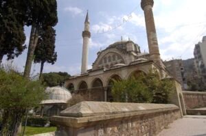
- Tekke Mosque. It is the central building of the Canbolad Pasha complex. Its main dome is 14.40 metres across. The Culture Portal calls it the largest dome in Kilis. Its original pulpit dates to 1553 and is decorated with plant and geometric patterns in coloured marble.
- Old Bath (Eski Hamam). Its inscription says Emir Canbolat, son of Emir Kasım, had it built in 1562. It stands in the Meşetlik neighbourhood.
- Tuğlu Bath. Daldabanzade Mehmet Pasha built it in 1785, in the Şeyhler neighbourhood.
- Great Mosque (Ulu Camii). It has a rectangular plan, and the dome in front of its prayer niche is 7.30 metres across. The Aleppo-born architect Hacı Ahmet Azizi repaired it in 1924.
Houses built around a courtyard
Here is the everyday-life link. Imagine you live in an old Kilis house. You would spend your day in the courtyard, called a havuş. Daily life centres on it, so most windows open onto the courtyard rather than the street.
Many walls are made of lef, a dirty-white building stone from local quarries. The municipality lists Salih Efendi Street, Hacı Ömer Ağa Street and Akcurun Avenue among the historic areas with traditional stone houses. Salih Efendi Street is also recorded as Kabaltı in the Ministry of National Education’s list of out-of-school learning sites.
The municipality’s inventory dates the Akıncı Mansion to 1895 and the Neşet Efendi Mansion to 1924–1925. Walk the lanes with those dates in mind. You are looking at buildings from the final years of Ottoman rule and the first years of the Republic.
Occupation and liberation, 1918–1921
After the First World War, a British occupation began in Kilis in December 1918. On 29 October 1919 it gave way to a French occupation.
The end of the French presence is told with two dates. A study by Mustafa Can, published by the Turkish Academy of Sciences (TÜBA), says Kilis was handed to the national forces on 7 December 1921. The TDV Encyclopedia of Islam says the French withdrawal started on that day and the liberation was completed on 23 December. Both agree on the month and year. They differ on what the 7th means.
Kilis becomes a province
In 1995 Kilis was separated from the southern part of Gaziantep province and became a province itself.
Timeline
- Late Chalcolithic Age: Settlement layers form at Oylum Höyük.
- About 4,500 years ago: The charred olive stones found at Oylum Höyük date to this period.
- 1097: Baudouin de Boulogne takes Ravanda Castle.
- 1151: Ravanda Castle comes under Nureddin Mahmud.
- 1516: After the Mercidabık victory, Kilis and its surroundings enter Ottoman rule.
- 1519: The Ottoman survey records Killiz with six neighbourhoods.
- 1553: The coloured-marble pulpit of the Tekke Mosque is made.
- 1562: Emir Canbolat has the Old Bath built.
- 1785: The Tuğlu Bath is built.
- 1880: The soap-house building, later the Kilis Museum, is built.
- December 1918: The British occupation begins.
- 29 October 1919: French occupation replaces British occupation.
- 7 December 1921: Kilis is handed to the national forces (TÜBA); the French withdrawal begins (TDV).
- 23 December 1921: The liberation is completed, according to TDV.
- 30 May 1926: The border south of Kilis moves 4–5 kilometres south.
- 1987: Rescue excavations start at Oylum Höyük.
- 1995: Kilis becomes a province.
Details you won’t find in guidebooks
- A museum that was a soap factory. The Kilis Museum occupies an 1880 soap-house building. It was known as Kalaycılar Mahsarası and made soap on a commercial scale.
- A bath with a nickname. You go down nine stone steps from street level to enter the Hasanbey Bath. That is why people also call it the Çukur Hamam, the “Sunken Bath”.
- A rescue dig with a protective purpose. The 1987 work at Oylum Höyük was meant partly to stop villagers from damaging the mound.
- A date that depends on the source. If you read about the 1921 liberation, check which source gives which day: 7 December or 23 December.
- A border that moved. The 1926 protocol shifted the line south of Kilis by 4–5 kilometres.
FAQ
What was Kilis called in Ottoman records?
The 1519 Ottoman survey wrote the town’s name as Killiz. A medieval geography book also gives the form Killiz and describes it as a village attached to Azaz.
Does the name Kilis come from ancient Cyrrhus?
One theory says so. It reads Cyrrhus as Kiris and explains the change through Turkmen pronunciation. Historian Hasan Yenidoğan says claims linking the name to Kiliza, Kyrrhos or Kenîset have no historical basis, so the question stays open.
When did the Ottomans take Kilis?
Kilis and its surroundings came under Ottoman rule after Yavuz Sultan Selim’s victory at Mercidabık in 1516. By the 1519 survey the town had six neighbourhoods and about 1,500 people.
When was Kilis liberated from the French?
Sources differ. A TÜBA study says Kilis was handed to the national forces on 7 December 1921. The TDV Encyclopedia of Islam says the French withdrawal began that day and was completed on 23 December.
When did Kilis become a province?
Kilis became a province in 1995, when it was separated from the southern part of Gaziantep province.
Sources
- Wikipedia (Turkish) — Kilis tr.wikipedia.org
- Kilis Directorate of Environment, Urbanisation and Climate Change — Kilis Adı kilis.csb.gov.tr
- Kilis 7 Aralık University — Orta Çağ’da Kilis ve Ravanda Kalesi kilis.edu.tr
- TDV İslâm Ansiklopedisi — Kilis islamansiklopedisi.org.tr
- Kültür Portalı — Kilis Genel Bilgiler kulturportali.gov.tr
- Kültür Portalı — Oylum Höyük kulturportali.gov.tr
- Ministry of Culture and Tourism — Engin Özgen, Oylum Höyük 1987 ukaas.ktb.gov.tr
- Ministry of Industry and Technology — Kilis Zeytin ve Zeytinyağı Tanıtım Günü sanayi.gov.tr
- Kültür Portalı — Ravanda Kalesi kulturportali.gov.tr
- Kilis Municipality — Tarihi Konaklar kilis.bel.tr
- Ministry of National Education — Kilis Okul Dışı Öğrenme Ortamları okuldisiogrenme-cdn-large.eba.gov.tr
- Ministry of Culture and Tourism, Turkish Museums — Kilis Müzesi turkishmuseums.kprod.kultur.gov.tr
- Kültür Portalı — Ulu Camii kulturportali.gov.tr
- Kültür Portalı — Tekke Camisi / Tekye Camisi kulturportali.gov.tr
- Kilis Governorate — Hamamlar kilis.gov.tr
- Turkish Academy of Sciences (TÜBA) — Mustafa Can, Kilis’in İşgali ve Kurtuluşu tuba.gov.tr