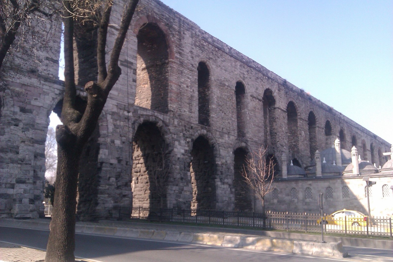
If you walk down Atatürk Boulevard in Istanbul, you pass under a Roman structure without leaving the pavement. The Valens Aqueduct, called Bozdoğan Kemeri in Turkish, carries cars, buses and pedestrians beneath its arches. It has stood over this road far longer than there has been a road.
This guide explains what the aqueduct is, how long and tall it is, who repaired it, and which parts of its story are still argued over.
Valens Aqueduct in Istanbul: where it stands
The aqueduct is in Istanbul’s Fatih district, in the Saraçhane area. The Ministry of Culture and Tourism’s Culture Portal lists its address as Kalenderhane.
Atatürk Boulevard passes between the structure’s piers.
The arches cross the valley between the third and fourth hills of the old city. Today Istanbul University stands on one of those hills and the Fatih Mosque on the other. If you are using a map, look for the point where the boulevard runs through the valley between those two landmarks.
What was the Valens Aqueduct of Constantinople for?
Its job was simple. It brought water from outside the city across the low ground between Fatih and Beyazıt. The water ended in the main reservoir at Beyazıt.
The arches carried the channel across the valley so that the water kept moving toward the reservoir.
The need was real. Under Constantine I, Constantinople grew. More people meant the existing water network had to be extended.
Think of the tap in your kitchen. You open it and water comes out. In the Roman city, someone had to build a bridge across a valley to make that possible.
Valens Aqueduct in the 4th century: who built it and when?
The aqueduct is called the Valens Aqueduct because it is attributed to the reign of the Roman emperor Valens, who ruled from 364 to 378.
The exact year of completion is not settled. The Culture Portal gives 378. The history section of English Wikipedia gives 368. The same article’s introduction gives 373.
Because the sources disagree, this article does not pick one year. What is safe to say is that the aqueduct belongs to the 4th century and to the reign of Valens.
Valens Aqueduct length, height and arches
The numbers below come from Turkish and English Wikipedia.
- Standing length: 921 metres.
- Earlier length: about 971 metres. That is 50 metres more than what remains.
- Height: the highest point rises about 29 metres above the ground.
- Slope: the water channel falls at 1:1000. That is a drop of one metre for every thousand metres.
- Two-storey arches: the openings numbered 18 to 73 have two levels.
That gentle slope matters. Water in an open channel needs a steady, small fall. Too steep and it rushes. Too flat and it stops.
The Valens Aqueduct system: a much bigger network
The arches in Fatih are only the part you can see. They belong to a much larger system.
A 2021 announcement from Johannes Gutenberg University Mainz describes Constantinople’s expanded water system. It was a network of channels at least 426 kilometres long.
The same research says the expansion in the 5th century brought in sources 120 kilometres from Constantinople.
The network also had:
- 90 large bridges;
- tunnels up to 5 kilometres long.
In that context, the Valens Aqueduct is the monumental section inside the city. It sits at the end of a very long line.
Why is it called Bozdoğan?
The name Bozdoğan is a puzzle. In the foundation deeds of Mehmed the Conqueror, the structure is called simply “Kemer”, meaning “the Arch”. Nobody knows exactly when it became Bozdoğan.
One theory links the name to “Bozulgan Kemer” on a map from 1607. Semavi Eyice does not find other explanations convincing. These include a falcon, a pear and a mace.
So you can treat the name as an open question. The structure itself is much easier to explain than its nickname.
Repairs: from the Avars to the Ottomans
The aqueduct was not built once and left alone. People kept repairing the system for centuries.
In 626, during the Avar siege, water facilities outside the city walls were destroyed. After a drought in 758, Constantine V made repairs and water flowed again.
In 1019, under Basil II, maintenance and repair work was carried out on the aqueduct.
After the conquest of 1453, Mehmed the Conqueror had it repaired. The water went first to the Old Palace and then to Topkapı Palace.
Later, under Suleiman the Magnificent, new water lines came in from the Belgrade Forest. The documented link between Mimar Sinan and the aqueduct is that he connected these lines to the system.
Timeline
- 4th century: The aqueduct is completed in the reign of Valens. Sources disagree on the exact year.
- 5th century: Constantinople’s water network is extended to more distant sources.
- 626: The Avar siege destroys water facilities outside the walls.
- After 758: Constantine V repairs the system after a drought.
- 1019: Basil II orders maintenance and repair of the aqueduct.
- 1403: The envoy Clavijo reports that the aqueduct’s water helps irrigate the surrounding vineyards and gardens.
- After 1453: Mehmed the Conqueror has the system repaired to serve the palaces.
- 1509: An earthquake strikes. Eyice names it as the likely reason for the damage to the aqueduct.
- Reign of Suleiman: Mimar Sinan connects new water lines from the Belgrade Forest to the system.
- 2009: Geophysical surveys reveal how deep the foundations lie.
- 2021: The Mainz University team’s research on limescale deposits and network maintenance is announced.
Details you won’t find in guidebooks
Gardens along the route. The Castilian envoy Clavijo wrote about his journey in 1403. He reports that the aqueduct’s water also helped irrigate the surrounding vineyards and gardens.
Foundations below the street. Geophysical surveys in 2009 found that the foundations of the piers lie about 5.4 to 6 metres below today’s ground level. The street you walk on is higher than the Roman ground.
Thin limescale. Gül Sürmelihindi’s team studied the wider water network. They found only thin layers of limescale, equal to about 27 years of buildup. The system worked for centuries, so this means it was cleaned regularly.
A spare channel. The researchers suggest that a 50-kilometre double-channel section may have kept water flowing while the other channel was being cleaned.
Old views. English Wikipedia shows a 19th-century engraving by Joseph Clayton Bentley, made after a drawing by William Henry Bartlett. It is one of the older images of the aqueduct.
Three stories that do not hold up
Some popular stories about the aqueduct are weak on evidence.
The Şehzade Mosque story. One claim says the aqueduct was cut down so that the Şehzade Mosque would be visible. Semavi Eyice disagrees. He points to the 1607 map and says the likely cause is the earthquake of 1509.
The Kadıköy stones story. Another claim says the aqueduct was built from stones taken from the walls of Kadıköy. Eyice writes that he found no convincing support for this.
The single clear date. Many pages state one completion year as fact. As shown above, the sources do not agree.
Visiting the Valens Aqueduct
The aqueduct stands in Fatih, so you can see it from the boulevard.
Walk along the pavement and look up at the arches. Then look at the traffic passing between the piers. A water channel from late antiquity still stands over a modern road.
The Culture Portal’s photograph of the aqueduct is credited to the Promotion General Directorate Archive and photographer Gülcan Acar.
FAQ
How long is the Valens Aqueduct?
About 921 metres still stand. Before it lost sections, it measured roughly 971 metres. Its highest point rises about 29 metres above the ground.
When was the Valens Aqueduct completed?
Sources disagree. The Turkish Culture Portal gives 378, English Wikipedia’s history section gives 368, and its introduction gives 373. The aqueduct is linked to Emperor Valens, who ruled from 364 to 378.
Why is it called Bozdoğan Kemeri?
Nobody knows for certain when it took the name. One theory ties it to “Bozulgan Kemer” on a 1607 map. Semavi Eyice does not find the falcon, pear or mace explanations convincing.
Where is the Valens Aqueduct in Istanbul?
It is in the Fatih district, in the Saraçhane area. Atatürk Boulevard runs between its piers. The arches cross the valley between the third and fourth hills.
Did the Ottomans use the aqueduct?
Yes. After the conquest of 1453, Mehmed the Conqueror had it repaired to supply the Old Palace and then Topkapı Palace. Mimar Sinan later connected new water lines from the Belgrade Forest to the system.
Sources
- Ministry of Culture and Tourism, Culture Portal — Bozdoğan Su Kemeri kulturportali.gov.tr
- Turkish Wikipedia — Bozdoğan Kemeri tr.wikipedia.org
- English Wikipedia — Aqueduct of Valens en.wikipedia.org
- TDV Islamic Encyclopedia — Semavi Eyice, Bozdoğan Kemeri islamansiklopedisi.org.tr
- Johannes Gutenberg University Mainz — research announcement idw-online.de
Image: Hadrianus Bozdoğan Kemeri 4.jpg — İncelemeelemani, CC BY-SA 3.0