If you search for the history of Hatay, you quickly find a place with many layers. Hatay is a province. Antakya is the city that serves as its administrative center. The two names are often mixed up, and the difference matters when you read about the past.
This guide walks you through the main periods, explains how the name Hatay appeared, and points you to the places that carry the story.
Hatay history: the short version
The Governorship of Hatay dates the start of human settlement in the region to about 100,000 BC, in the Middle Paleolithic period. That is a very long record for one province.
The cave of Üçağızlı I gives a sense of how long people stayed. A cultural deposit about four meters thick there shows that Pleistocene people used the cave without a break for 12,000 years.
Later, the Amik Plain held a Late Hittite-Aramean kingdom, known as Patina or Unqi. The Tayinat excavation project of the University of Toronto identifies Tell Tayinat as its capital, Kunulua. Excavators found a statue of King Šuppiluliuma, who ruled in the 9th century BC, along with stone objects carved in Luwian hieroglyphs.
Hatay Turkey history: from Antiokheia to the Ottomans
The city of Antakya begins in 300 BC. Seleukos Nikator, known as Seleucus I, founded it and named it Antiokheia after his father, Antiokhos.
From 64 BC, the city became one of the main regional centers of the Roman Empire. Rome shaped the coast too, as the next section shows.
The later centuries brought a long run of rulers:
- In 638, Antakya passed to Muslim Arab rule.
- In 969, the Byzantines took it back.
- In 1084, Süleyman Shah of the Anatolian Seljuks captured it.
- In 1098, the Crusaders took the city, and it became the center of the Principality of Antioch.
- In 1268, the Mamluks took control of the region.
- In 1516, the Ottoman Sultan Selim I added it to his realm.
One small find shows how coins and trade crossed this city. An excavation in Antakya in 2011–2012 uncovered 17 silver dirhams, published in 2024. Five date to the Abbasid period, seven to the Buyid period and five to the Samanid period.
Hatay historical places you can still read about
Several sites tell different parts of the story.
Tell Tayinat. This mound in the Amik Plain is the Late Hittite-Aramean capital described above. It is the place to start if you want the period before the Seleucids.
The Vespasian-Titus water diversion system. It stands at Çevlik in Samandağ. Romans built it to protect the harbor of Seleukeia Pieria from filling up with silt carried down by floods from the mountains. Work began under Vespasian in the 1st century AD. It continued under Titus and his successors and was completed in the 2nd century AD under Antoninus Pius. On 15 April 2014, it was submitted to Türkiye’s UNESCO World Heritage Tentative List.
St. Pierre Church. It lies on the western slope of Mount Stauris in Antakya. Pope Paul VI declared it a pilgrimage site in 1963.
The Habib-i Neccar Mosque. The Culture Portal links its early foundation to 638. The same portal’s building inventory gives a construction date of 1285. These are likely different building phases, so read each date as belonging to its own phase. The portal dates the fountain in the courtyard to the 19th century.
Uzun Çarşı. This long market in Antakya is the place where history meets daily life. It is covered in the sections below.
Where the name Hatay comes from
The name is much younger than the city. On 2 November 1936, Atatürk told Tayfur Sökmen that Antakya, İskenderun and their surroundings would from then on be called Hatay.
Where did the word itself come from? Historians give more than one answer.
One view links it to the Hattena Kingdom. The Hatay Governorship repeats this idea but does not present it as certain.
Another reading does not treat Hatay as the unbroken survival of an ancient name. It explains the name as a choice made in the 1930s, in the setting of the Turkish History Thesis, with links to Ata, Eti and Hittite names.
Either way, the name was announced on 2 November 1936, so it is a modern label for a very old landscape.
How Hatay joined Türkiye in 1939
The road to 1939 started earlier. Under the Ankara Agreement of 20 October 1921, the Sanjak of Alexandretta stayed outside Türkiye’s borders but received a special administrative status.
Then came the Hatay State period. The Hatay State Assembly met on 2 September 1938 at the Gündüz Cinema in Antakya and elected Tayfur Sökmen as head of state.
A historic government and assembly building in Antakya was built in 1927–1928. After restoration, it opened in 2011 as the Hatay Governorship.
The union itself had three separate steps in 1939:
- On 29 June, the Hatay National Assembly unanimously approved joining Türkiye.
- On 7 July, Law No. 3711 created the province of Hatay. Dörtyol and Hassa were attached to it.
- On 23 July, the last French unit left, and the Turkish flag was raised at the Antakya Barracks.
That last date is still marked as the anniversary of Hatay’s joining Türkiye.
Timeline
- About 100,000 BC: The start of settlement in the region, as dated by the Hatay Governorship.
- 9th century BC: The reign of King Šuppiluliuma, whose statue was found at Tell Tayinat.
- 300 BC: Seleukos Nikator founds Antiokheia.
- 64 BC: Antakya enters Roman rule.
- 1st–2nd centuries AD: The Vespasian-Titus water diversion system is built.
- 638: Muslim Arab rule begins.
- 969: The Byzantines retake the city.
- 1084: Süleyman Shah captures Antakya.
- 1098: The Crusaders take the city.
- 1268: The Mamluks take control.
- 1516: The region enters Ottoman rule.
- 20 October 1921: The Ankara Agreement leaves the Sanjak of Alexandretta outside Türkiye, under a special status.
- 2 November 1936: Atatürk announces the name Hatay.
- 2 September 1938: The Hatay State Assembly meets and elects Tayfur Sökmen head of state.
- 29 June 1939: The Hatay National Assembly votes to join Türkiye.
- 7 July 1939: Law No. 3711 creates the province of Hatay.
- 23 July 1939: The last French unit leaves.
- 1963: St. Pierre Church is declared a pilgrimage site.
- 15 April 2014: The Vespasian-Titus Tunnel is submitted to the UNESCO Tentative List.
- 6 February 2023: The earthquakes centered on Pazarcık and Elbistan.
- 20 February 2023: A magnitude 6.4 earthquake hits the Defne district at 20.04.
Details you won’t find in guidebooks
The “tunnel” is mostly open channel. The system called the Titus Tunnel measures about 875 meters. Only 121 meters of it consist of the two closed tunnels. The rest is open, so the name gives a smaller picture than the real work.
A cave used for 12,000 years. The four-meter deposit in Üçağızlı I is a layered record of daily life, built up over twelve thousand years of continuous use.
Streets sorted by trade. In Antakya’s Uzun Çarşı, shoemaking, weaving and other trades gather in separate streets. The Hatay Governorship describes this as a division of work that recalls Ottoman guild organization. You know this pattern from any market where all the shoe sellers sit on one lane. It is a living echo of the guild system, and you can still walk through it.
Smuggling in the modern era. On 22 December 2015, officials seized a vehicle in Reyhanlı. Specialists identified 5,108 of the objects inside as historical artifacts. They were handed to the Hatay Museum Directorate.
A mound that holds a capital. Tell Tayinat looks like an ordinary hill. Toronto’s excavations tie it to Kunulua, the capital of a kingdom, and the finds include a royal statue.
The 2023 earthquakes
The earthquakes of 6 February 2023 caused major destruction in Hatay. According to AFAD, the first struck at 04.17, centered on Pazarcık, with a magnitude of Mw 7.7. The second struck at 13.24, centered on Elbistan, with a magnitude of Mw 7.6.
On 20 February 2023, AFAD’s first press bulletin reported a magnitude 6.4 earthquake in Hatay’s Defne district at 20.04.
The archaeological and architectural heritage of Hatay was badly damaged. If you plan a trip, check current access to each site before you go.
FAQ
What is the difference between Hatay and Antakya?
Hatay is the name of a province. Antakya is the city that serves as the administrative center of that province.
When did Hatay become part of Türkiye?
It happened in stages in 1939. The Hatay Assembly voted to join on 29 June, a law created the province on 7 July, and the last French unit left on 23 July.
Who founded Antakya?
Seleukos Nikator founded it in 300 BC. He named it Antiokheia after his father, Antiokhos.
Where does the name Hatay come from?
Atatürk announced the name on 2 November 1936. Some sources link it to the Hattena Kingdom, while another reading sees it as a 1930s naming tied to the Turkish History Thesis and to Hittite connections.
What are the most important historical places in Hatay?
Key sites include Tell Tayinat in the Amik Plain, the Vespasian-Titus water diversion system at Çevlik, St. Pierre Church, the Habib-i Neccar Mosque and the Uzun Çarşı market in Antakya.
Sources
- Wikipedia — Hatay Province en.wikipedia.org
- Hatay Governorship — Hatay’s Name Story hatay.gov.tr
- Hatay Governorship — The City of All Times: Hatay hatay.gov.tr
- Karadeniz Technical University AVESİS — Üçağızlı I Cave Research Project avesis.ktu.edu.tr
- University of Toronto — Tayinat Archaeological Project tayinat.artsci.utoronto.ca
- UNESCO World Heritage Centre — Vespasianus Titus Tunnel whc.unesco.org
- Ministry of Culture and Tourism — St. Pierre Monument Museum muze.gov.tr
- Culture Portal — Habib-i Neccar Mosque building inventory kulturportali.gov.tr
- Culture Portal — Habibi Neccar Mosque kulturportali.gov.tr
- Hatay Governorship — Uzun Çarşı hatay.gov.tr
- Mustafa Kaya — Akdeniz İnsani Bilimler Dergisi dergipark.org.tr
- Balıkesir University — The Hatay question and the newspaper Türk Dili acikerisim.balikesir.edu.tr
- Atatürk Encyclopedia — Turkey-Syria Relations in Atatürk’s Era ataturkansiklopedisi.gov.tr
- Antakya District Governorship — Assembly Building antakya.gov.tr
- Hatay Governorship — Press Release on Antiquities Smuggling hatay.gov.tr
- AFAD — 6 February 2023 Earthquake Information Support System deprem.afad.gov.tr
- AFAD — Press Bulletin 1 on the 6.4 Magnitude Earthquake in Hatay afad.gov.tr
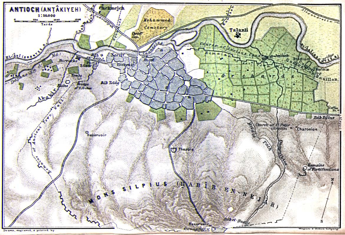
Image: AntiochMap1912.jpg — Unknown authorUnknown author, Public domain