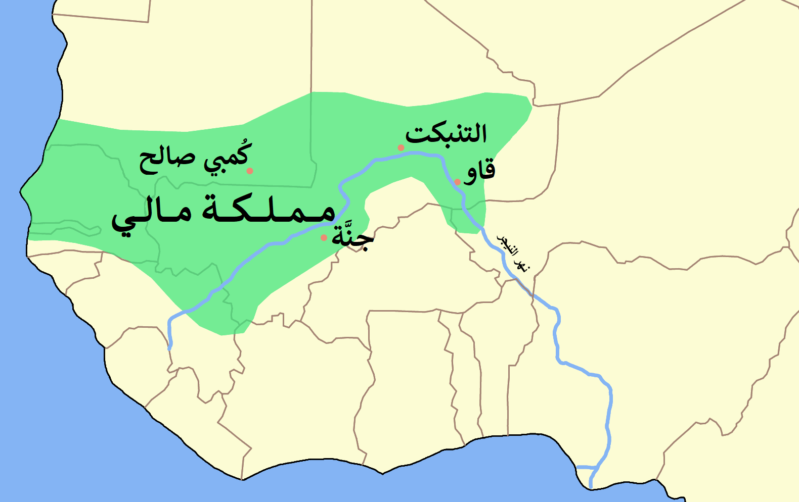
The Mali Empire stood in West Africa. It grew from a Mandinka kingdom in the Manding region of the upper Niger basin. Its historical territories extended beyond today’s Republic of Mali into areas of Senegal, The Gambia, Guinea and southern Mauritania.
Gold helped make this empire wealthy, but its economy also depended on trade centers and farming. Mansa Musa’s pilgrimage displayed that wealth abroad. Succession disputes and the loss of regional authority later weakened the empire over several centuries.
Mali Empire location: where was it on a map?
If you look for the Mali Empire on a modern map, begin with the upper Niger basin. The Manding region formed its original base. Kangaba, in southwestern Mali today, is one settlement within that historical core.
Then look beyond the borders of modern Mali. The empire’s territories reached into parts of present-day Senegal, The Gambia, Guinea and southern Mauritania. The modern country and the historical empire therefore cover different areas.
For a trade-focused Mali Empire map, OpenStax’s Map 3.6 offers a useful starting point. It places the Bambuk, Bure and Lobi goldfields alongside Saharan trade routes. You can use it to connect gold-producing areas with the routes through which wealth circulated.
Mali Empire history: how did it begin?
Mali’s imperial rise is conventionally traced to 1235. That year, Sundiata Keita defeated the Sosso ruler Sumanguru at the Battle of Kirina. His victory marked the beginning of Mali’s emergence as an imperial power.
Economic changes had already prepared the ground. By the late twelfth century, Saharan trade routes were bypassing Audaghost and turning toward the Bure goldfield. This shift weakened Ghana’s commercial dominance and helped create the conditions for Mali’s rise.
How gold built the Mali Empire’s wealth
Mali’s rulers gained gold through trade with producing regions and tribute collected from them. Access to those regions mattered, as did the routes connecting them to wider markets. Gold wealth depended on these relationships between production, exchange and political authority.
Control of trading cities was another priority. Mali’s rulers sought authority over Oualata, Gao, Timbuktu and Djenné. These centers connected Saharan commerce with the regional economy. Their importance helps explain why later losses of cities weakened imperial power.
Gold and salt remained major means of exchange in long-distance trade. Other goods also moved through Mali’s networks. These included textiles, ivory and shea butter. Enslaved people were traded through the same networks.
Agriculture supported this commercial wealth. Mali’s economy depended partly on production in the southern savannas, alongside access to Bure gold and trade routes. An account centered entirely on gold leaves out this agricultural foundation.
Mali Empire Mansa Musa: why did his pilgrimage matter?
Musa Keita became mansa around 1312. The title means ruler in the Malinke language. He undertook his pilgrimage to Mecca between 1324 and 1326, traveling through Cairo.
In Cairo in 1324–1325, Musa distributed and spent enough gold to reduce its value in the city. This episode gives a concrete example of the scale of wealth associated with his journey. His spending affected the place through which he traveled.
Musa’s pilgrimage also connects with architecture in Timbuktu. UNESCO attributes the initial construction of the Djingareyber Mosque to Sultan Kankan Musa after his return from the pilgrimage. His reign therefore appears in both accounts of gold circulation and the history of a surviving religious monument.
The Mali Empire at its peak
Mali reached the height of its power during the fourteenth century. Around 1350, its area is estimated at approximately 1.3 million square kilometers. That figure is an estimate of its historical extent.
The empire’s power drew on several connected resources. Gold-producing regions supplied trade and tribute. Cities linked regional commerce to Saharan routes. Southern savanna farming supported the economy beneath these exchanges.
Mali Empire religion: Islam and traditional beliefs
Islam and traditional African beliefs coexisted within Mali. Northern regions nearer the Sahara were more Islamized than southern regions. Religious practice therefore varied across the empire’s territory.
Mansa Musa’s pilgrimage provides a clear example of Islam at the royal level. Yet royal involvement in Islam did not mean that all communities followed the same religion. Gold production offers a particularly revealing example of this coexistence.
Mali’s rulers did not encourage gold producers to convert to Islam because prospecting and production were tied to traditional rituals. Religious policy in these communities was closely connected to an activity that supplied imperial wealth.
Mali Empire capital: why is Niani disputed?
Niani, in Guinea, is a disputed candidate for the imperial capital. In a 1981 study, Władysław Filipowiak identified some excavated structural remains there with buildings commissioned by Mansa Musa in the fourteenth century.
François-Xavier Fauvelle-Aymar challenged that interpretation in his 2012 article, Niani Redux. He concluded that the archaeological evidence did not support Niani as the fourteenth-century imperial capital. If you encounter Niani labeled as the capital, this disagreement matters to how you read that claim.
Mali Empire architecture: what does Timbuktu preserve?
Timbuktu’s Djingareyber, Sankore and Sidi Yahia mosques are important examples of earthen architecture. Traditional maintenance methods sustain these buildings. Their preservation involves continued care of the structures.
Their architectural histories also include later changes. Sankore Mosque was built in the fourteenth century. During a renovation between 1578 and 1582, Imam Al Aqib rebuilt its sanctuary according to the dimensions of the Kaaba in Mecca.
Djingareyber’s initial construction is associated with Musa’s return from pilgrimage. Sankore’s later rebuilding belongs to a different period. Keeping those stages separate helps you understand that Timbuktu’s religious buildings developed over time.
Mali Empire flag: what is actually recorded?
An account of Musa’s Cairo visit describes a banner with a yellow symbol on a red background. Modern drawings based on that description are possible reconstructions. They should be understood in relation to the reported banner rather than treated as certain reproductions.
Why did the Mali Empire decline?
Disputes over succession within the ruling dynasty were a major cause of weakened central government. Regional challenges compounded that weakness. Between 1374 and 1387, rebellions in Takedda and Gao exposed problems in Mali’s authority over important production and trading centers.
By the 1430s, Mali had lost control of Timbuktu. The northern dependent kingdom of Mema had also become independent. These losses show a process of territorial and political fragmentation across successive periods.
A later attempt to recover regional power ended at Djenné. On 26 April 1599, forces of the Moroccan Sultanate and its dependent Pashalik of Timbuktu defeated Mahmud IV’s army. The defeat broke apart his temporary alliance and ended that recovery attempt.
For readers interested in Ottoman history, the identity of those forces matters. The army that defeated Mali at Djenné belonged to Morocco and the Pashalik of Timbuktu. It was not the Ottoman army.
Accounts differ over the endpoint: the English Wikipedia article uses 1610, while the Turkish article places the end around 1670. The earlier losses of cities and dependent territories show why decline cannot be reduced to one battle.
Timeline
- 1235: Sundiata Keita defeats Sumanguru at Kirina.
- Around 1312: Musa Keita becomes mansa.
- 1324–1326: Mansa Musa travels through Cairo on pilgrimage to Mecca.
- Around 1350: Mali reaches an estimated area of 1.3 million square kilometers.
- 1374–1387: Rebellions challenge Mali’s rule in Takedda and Gao.
- By the 1430s: Mali has lost control of Timbuktu, and Mema has become independent.
- 26 April 1599: Mahmud IV’s army is defeated near Djenné.
- 1610 or around 1670: The English and Turkish Wikipedia articles give different dates for Mali’s end.
Details you won’t find in guidebooks
The Catalan Atlas of 1375 depicts Mansa Musa holding a golden object opposite a camel trader. The image brings the ruler, gold and trade together in a single representation.
Cowrie shells brought from the East African coast began circulating as local money in Mali during the fourteenth century.
The gold producers’ traditional rituals also affected royal religious policy. Rulers avoided encouraging their conversion to Islam because those rituals were connected to prospecting and production. The relationship between belief and wealth extended beyond Musa’s pilgrimage.
FAQ
Where is the Mali Empire today?
Its historical territories extended across parts of present-day Mali, Senegal, The Gambia, Guinea and southern Mauritania. Kangaba, in southwestern Mali, lies within its historical core.
How did the Mali Empire become wealthy?
Trade with gold-producing regions and tribute from those regions supplied much of its gold wealth. Control of trade centers and agricultural production in the southern savannas also supported its economy.
Was Niani the Mali Empire’s capital?
Niani is a disputed candidate. Władysław Filipowiak linked excavated structures there to Mansa Musa, but François-Xavier Fauvelle-Aymar concluded that the archaeological evidence did not support Niani as the fourteenth-century imperial capital.
Did the Ottoman army defeat Mali in 1599?
No. On 26 April 1599, Mahmud IV’s army was defeated near Djenné by forces of the Moroccan Sultanate and its dependent Pashalik of Timbuktu.
Sources
- Wikipedia — Mali Empire en.wikipedia.org
- Vikipedi — Mali İmparatorluğu tr.wikipedia.org
- Wiley — Nana Yaw B. Sapong, Mali Empire onlinelibrary.wiley.com
- OpenStax — The Roots of African Trade openstax.org
- OpenStax — Medieval Sub-Saharan Africa openstax.org
- The Metropolitan Museum of Art — The Trans-Saharan Gold Trade metmuseum.org
- Smithsonian Libraries and Archives — Le complex du palais royal du Mali si.edu
- Palethnologie — Niani Redux journals.openedition.org
- UNESCO World Heritage Centre — Timbuktu whc.unesco.org
- Wikipedia — Battle of Jenné en.wikipedia.org
- Wikipedia — Kangaba en.wikipedia.org
Image: MALI empire map-ar.png — Original: Astrokey44
Derivative work: باسم, CC BY-SA 3.0