In May 1838, soldiers under General Winfield Scott began pulling Cherokee families out of their homes in Georgia, Tennessee, Alabama and North Carolina. More than 16,000 people were forced out. By the end of March 1839 the survivors were in present-day Oklahoma. The road between those two points is what people call the Trail of Tears.
The name is wider than one nation. It also covers the forced removal of the Choctaw, Muscogee, Chickasaw and Seminole peoples. This article follows the Cherokee story, because the 1838–1839 removal is the one most searchers mean. If you plan to walk part of the trail, or you are writing a school paper, the sections below give you the dates, the places and the people.
Trail of Tears president: Jackson signed, Van Buren enforced
Two presidents share the responsibility. Andrew Jackson signed the Indian Removal Act on 28 May 1830. The law authorized the exchange of native lands east of the Mississippi River for lands in the west. Jackson’s successor, Martin Van Buren, gave General Winfield Scott the final order in May 1838.
So when you read “the Trail of Tears president”, the answer depends on the question. Jackson created the legal tool. Van Buren used it.
Trail of Tears Georgia: gold, lotteries and a court ruling
Georgia was the center of the pressure. The Cherokee Nation had adopted a written constitution in 1827, modeled on the US Constitution. Its capital was New Echota, near present-day Calhoun, from 1825 until the removal. Then gold was found on Cherokee land in 1829. White settlers wanted the land more than ever.
In 1832 Georgia held land lotteries to hand out Cherokee land it had seized. The same year the US Supreme Court ruled in Worcester v. Georgia that Georgia’s laws could not be enforced inside the Cherokee Nation. The ruling and the lotteries came in the same year. The land kept changing hands.
The treaty the Cherokee majority never accepted
On 29 December 1835 twenty pro-treaty leaders signed the Treaty of New Echota. They had no authority from the Cherokee government. The treaty handed all Cherokee land east of the Mississippi to the United States for 5 million dollars and new land in present-day Oklahoma.
Most Cherokee opposed it. In May 1836 the US Senate ratified it anyway. The required majority was reached by a single vote. The treaty gave the Cherokee until May 1838 to leave. Because the majority never recognized the treaty, most people stayed. That deadline is why the removal starts in May 1838.
Trail of Tears date: May 1838 to March 1839
The key date is May 1838. That is when about 7,000 soldiers under General Winfield Scott began removing families and sending them to holding camps. Some families were given only a few minutes to gather their belongings. White looters followed the soldiers and stripped the empty houses.
Think about how long you need to pack for a weekend away. Most people take an hour or more. These families had minutes, and they were not coming back.
The Cherokee were held at three main emigration depots: two in Tennessee and one in Alabama. Conditions were poor. People died of disease in the camps before the journey even began.
The forced removal ended in late March 1839. Survivors then began to resettle in present-day Oklahoma.
Trail of Tears route: where did it start and end?
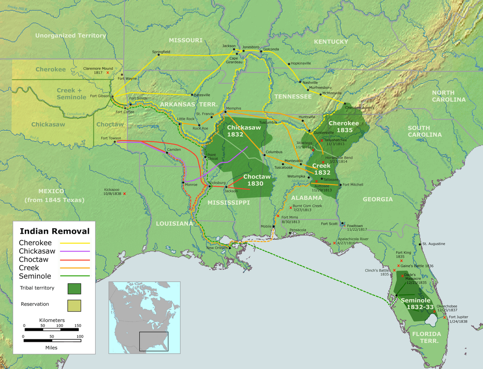
The trail started in the Cherokee homeland in Georgia, Tennessee, Alabama and North Carolina. It ended in Indian Territory, in present-day Oklahoma. There was no single road. There were several land and water routes.
In June 1838 three Cherokee groups left southeastern Tennessee and traveled west by water. Then the summer of 1838 brought drought. River levels dropped and transport stalled. The Cherokee asked for the removal to be postponed until autumn. The request was granted on the condition that they stay in the camps.
That summer, after John Ross negotiated with Winfield Scott, responsibility for managing the later groups passed to the Cherokee leadership. Most people then traveled west on foot, on horseback or in wagons. One of the common land routes ran about 800 miles, or 1,287 kilometers. Some groups covered part of the distance by train on one of the early US railroads.
Winter caught the later groups at the Mississippi River. In the winter of 1838–1839, floating ice stopped the crossing near today’s Trail of Tears State Park in Missouri. Groups camped on both banks and waited.
Trail of Tears map
The National Park Service runs the official map page. It links to interactive ArcGIS maps that let you follow each separate route. If you want to compare the water route from Tennessee with the long overland route through Missouri, that is the place to start.
Trail of Tears National Historic Trail
Congress created the Trail of Tears National Historic Trail in 1987 to commemorate the Cherokee removal routes. In 2009 additional routes were added to the trail system. The National Park Service publishes the trail brochure and the maps that describe these routes.
Trail of Tears State Park
Trail of Tears State Park lies on the Mississippi River in Missouri. This is where ice stopped the crossing in the winter of 1838–1839. Groups camped on both sides of the river until the crossing reopened. The Missouri State Parks history page covers this episode.
How many died?
Nobody knows the exact number. The Cherokee Nation reports about 4,000 deaths. The National Park Service history summary counts more than a thousand deaths on the journey itself. It treats deaths caused by the removal’s aftermath separately: an unknown number, probably several thousand more. The camps, disease and the hard journey all contributed.
What happened after 1839
The survivors rebuilt their government. On 6 September 1839 Cherokee delegates signed a constitution for the reunited Cherokee Nation. Tahlequah became the new capital.
Not everyone was removed. In Tennessee and North Carolina about 1,000 Cherokee escaped the roundup of 1838. These communities later took part in forming the Eastern Band of Cherokee Indians.
Trail of Tears book
Looking for a serious read? The National Park Service bibliography lists Russell Thornton’s The Cherokees: A Population History, published in 1990. It examines the Cherokee population losses.
Timeline
- 1825 New Echota becomes the capital of the Cherokee Nation.
- 1827 The Cherokee Nation adopts a written constitution.
- 1829 Gold is found on Cherokee land. Pressure in Georgia grows.
- 28 May 1830 Andrew Jackson signs the Indian Removal Act.
- 1832 Worcester v. Georgia rules that Georgia’s laws cannot be enforced on Cherokee land.
- 1832 Georgia holds lotteries for seized Cherokee land.
- 29 December 1835 An unauthorized Cherokee group signs the Treaty of New Echota.
- May 1836 The US Senate ratifies the treaty by one vote.
- May 1838 Under Van Buren, General Scott’s troops begin the roundup.
- June 1838 Three groups leave Tennessee by water.
- Summer 1838 John Ross takes over management of the later groups.
- Autumn 1838 to winter 1839 Groups travel by land and water to present-day Oklahoma.
- Late March 1839 The forced removal is complete.
- 6 September 1839 The reunited Cherokee Nation signs its constitution.
- 1987 The Trail of Tears National Historic Trail is established.
- 2009 Additional routes are added to the trail system.
Details you won’t find in guidebooks
- The Cherokee carried ashes from their Sacred Fire with them during the 1838–1839 removal. The ashes stood for cultural continuity.
- The Senate vote in May 1836 reached the required majority by just one vote.
- Some groups rode part of the way on one of the earliest US railroads.
- In 1954 the University of Georgia archaeologist Clemens de Baillou was hired to locate the original building sites at New Echota.
- In 1992 the Cherokee Nation Council held its first council meeting on Georgia soil since 1830. The meeting was at New Echota.
FAQ
When was the Trail of Tears?
The Cherokee removal ran from May 1838 to late March 1839. The legal process began earlier, with the Indian Removal Act of 28 May 1830 and the Treaty of New Echota of 29 December 1835.
Who was president during the Trail of Tears?
Martin Van Buren. He gave General Winfield Scott the final order in May 1838. Andrew Jackson had signed the Indian Removal Act in 1830.
Where did the Trail of Tears start and end?
It started in the Cherokee homelands in Georgia, Tennessee, Alabama and North Carolina. It ended in present-day Oklahoma, where Tahlequah became the new capital in 1839.
How long was the Trail of Tears?
One common overland route ran about 800 miles, or 1,287 kilometers. Other groups traveled partly by river or by train.
How many Cherokee died on the Trail of Tears?
Estimates differ. The Cherokee Nation cites about 4,000 deaths. The National Park Service counts more than a thousand deaths on the journey itself and treats later deaths caused by the removal separately.
Sources
- National Park Service — Trail of Tears Brochure nps.gov
- National Park Service — What Happened on the Trail of Tears? nps.gov
- National Park Service — History & Culture nps.gov
- National Park Service — Transportation During the Cherokee Removal home.nps.gov
- National Park Service — Maps nps.gov
- National Park Service — Bibliography nps.gov
- Library of Congress — Indian Removal Act guides.loc.gov
- Cherokee Nation — History cherokee.gov
- Cherokee Nation — Our Journey cherokee.gov
- New Georgia Encyclopedia — Cherokee Indians georgiaencyclopedia.org
- Missouri State Parks — Park History mostateparks.com
- Georgia Department of Natural Resources — History of the State Parks and Historic Sites Division gastateparks.org
- Wikipedia — Trail of Tears en.wikipedia.org
- Wikipedia — New Echota en.wikipedia.org
- Vikipedi — Gözyaşı Yolu tr.wikipedia.org
Image: Trails of Tears en.png — User:Nikater, Public domain