What happened in the 1999 Düzce earthquake?
The 1999 Düzce earthquake struck on Friday, 12 November, at 18:57 local time. Only 87 days separated it from the 17 August İzmit earthquake. Düzce, Kaynaşlı and Bolu suffered deaths and severe building damage. For Düzce, November brought a second destructive earthquake within the same year.
The earthquake is commonly listed as moment magnitude Mw 7.2. Düzce Governorate’s 25th-anniversary message records 845 deaths. An official commemoration statement from Adıyaman Governorate gives 4,948 injuries. These figures describe a disaster whose effects extended beyond the initial shaking and into damaged streets, homes and emergency services.
If you are visiting Düzce, the dates 17 August and 12 November belong together in its recent history. Düzce University records 270 deaths in the region during the August earthquake. Its November account records another 710 deaths in Düzce and the seven districts now attached to it. The second disaster struck a region already counted among the losses of the first.
Why did a second disaster follow İzmit after 87 days?
The November earthquake occurred on the Düzce Fault. Sakarya University describes this fault as part of the northern branch of the North Anatolian Fault Zone. Its assessment connects the November rupture to the August earthquake through increased stress on the Düzce Fault.
According to that assessment, the November rupture formed an eastward extension of the İzmit earthquake rupture. The connection was therefore more than the short interval between two dates. The university’s explanation places both disasters within a linked sequence of fault rupture and changing stress.
Source-mechanism solutions indicate right-lateral strike-slip faulting. This describes the movement involved in the earthquake. It is a different part of the explanation from magnitude, which is commonly given as Mw 7.2, or the maximum reported Mercalli intensity of IX.
The 87-day interval is central to understanding Düzce’s losses. The university’s regional records list 1,157 injuries from August and 2,679 from November. Read together, those figures show why the November earthquake needs its own account while remaining connected to the earlier disaster.
Timeline
- 17 August 1999: The Marmara earthquake also devastated the Düzce region. Düzce University records 270 regional deaths.
- 12 November 1999, 18:57: A second destructive earthquake struck the Düzce Fault, 87 days after the August disaster.
- 9 December 1999: Düzce became Türkiye’s 81st province. The change aimed to accelerate redevelopment after both earthquakes.
- 2010: Konca and colleagues published a study comparing the fault trace identified in satellite imagery with the trace mapped in the field.
How strong was the earthquake?
The widely reported magnitude is Mw 7.2, but Sakarya University’s information paper gives Mw 7.1. When you encounter either figure, the source matters. Both describe the November earthquake, and the difference should remain visible when presenting its recorded magnitude.
The maximum reported Mercalli intensity was IX. This measures local shaking effects, whereas Mw 7.2 is a magnitude value. The two figures answer different questions. Keeping them separate helps you understand why an earthquake account can contain both a magnitude and an intensity without contradicting itself.
The recorded depth also varies by source. English Wikipedia, drawing on the ISC catalogue, gives 13.7 kilometres. Sakarya University reports a SABONET solution at 12.5 kilometres. Turkish Wikipedia lists 17 kilometres. A depth figure therefore needs an attribution rather than being presented as one settled value.
The ISC-based account gives the start time as 18:57:22 locally, or 16:57:22 UTC. Adıyaman Governorate’s commemoration statement describes 30 seconds of shaking. The precise start time and the reported duration provide separate details about an event generally remembered by the shorter time, 18:57.
How many people died, and why do the totals differ?
Düzce Governorate gives 845 deaths in its 25th-anniversary message about the November earthquake. Adıyaman Governorate’s official commemoration statement records 4,948 injuries. These are the broader figures used here for the disaster, distinct from the local totals published by Düzce University.
The university records 710 deaths and 2,679 injuries for Düzce and its present-day seven districts. That geographical scope matters. The earthquake also caused deaths and severe damage in Kaynaşlı and Bolu. A local count should not be treated as interchangeable with a broader earthquake total.
A separate Düzce Governorate message gives 980 deaths in Düzce province across the August and November earthquakes together. This matches the university’s regional death counts of 270 and 710 when added. The 980 figure belongs to both disasters, rather than to 12 November alone.
For students comparing accounts, the distinction is practical: 845 refers to the November death toll in the anniversary statement, while 980 is a combined provincial figure for both earthquakes. Keeping the date range and geographical coverage beside each number prevents separate records from becoming a misleading single total.
What happened to homes, workplaces and rescue routes?
Turkish Wikipedia attributes a damage inventory to the Prime Ministry Crisis Management Centre. It lists 12,939 homes and 2,450 workplaces as destroyed or severely damaged. These categories cover both places where people lived and places where they worked.
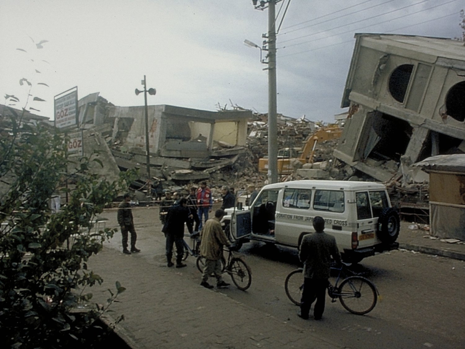
For an everyday-life connection, consider a trip from home to work or a journey to hospital. The disaster affected homes and workplaces, while building debris closed main streets in central Düzce. Vehicles carrying injured people to hospital became stranded on those roads.
The blocked streets made the building damage part of the emergency response problem. Injured people were being transported, but rubble interrupted their route to hospital. This concrete detail helps explain the consequences of collapsed buildings beyond the damage inventory itself.
Details you won’t find in guidebooks
Düzce’s Fire Department building collapsed during the earthquake. Personnel and vehicles were trapped beneath the debris. Crews arriving from surrounding districts were able to respond to fires because the local department had itself been struck by the disaster.
Düzce Municipality commemorates four firefighters who died: Güngör Başbay, Alim Sağlam, Cevat Yazgan and Hüseyin Kılıç. Their names give a human dimension to the account of the collapsed fire station. The emergency service’s losses included both its working capacity and members of its staff.
The fault trace also looks different depending on how it was observed. Konca and colleagues’ 2010 study identified approximately 55 kilometres using SPOT satellite imagery. The trace mapped in the field was approximately 40 kilometres long. The satellite observations revealed a longer trace than the ground mapping recorded.
Their best-fitting model found that rupture travelled eastward at an average of 3.7–3.8 kilometres per second, locally exceeding S-wave speed. Westward rupture travelled at about 3 kilometres per second. These are modelled rupture speeds, distinct from the reported 30-second shaking duration.
How did the earthquakes change Düzce’s status?
Düzce became Türkiye’s 81st province on 9 December 1999. The change aimed to accelerate redevelopment after the August and November earthquakes. The administrative milestone therefore belongs directly to the account of the disasters and their aftermath.
When you read about Düzce’s provincial status, the November earthquake provides essential context. The change followed two destructive earthquakes in the same year. Its stated purpose was to speed redevelopment in a place whose losses included homes, workplaces, blocked streets and a collapsed fire station.
FAQ
When did the 1999 Düzce earthquake happen?
It struck on Friday, 12 November 1999, at 18:57 local time, 87 days after the 17 August İzmit earthquake.
How strong was the Düzce earthquake?
Its moment magnitude is commonly reported as Mw 7.2, although Sakarya University gives Mw 7.1. Its reported maximum Mercalli intensity was IX.
How many people died in the Düzce earthquake?
Düzce Governorate’s 25th-anniversary message gives 845 deaths. Düzce University separately records 710 deaths for Düzce and its present-day seven districts.
Was the Düzce earthquake connected to the İzmit earthquake?
Sakarya University’s assessment states that the August earthquake increased stress on the Düzce Fault. The November rupture formed an eastward extension of the İzmit rupture.
Sources
- Turkish Wikipedia — 1999 Düzce depremi tr.wikipedia.org
- English Wikipedia — 1999 Düzce earthquake en.wikipedia.org
- Düzce University — 12 Kasım 1999 Düzce Depremi deprem.duzce.edu.tr
- Sakarya University — Düzce Depremi Bilgi Notu jfm.sakarya.edu.tr
- Adıyaman Governorate — Deprem Anı Ülke Tatbikatı adiyaman.gov.tr
- Düzce Governorate — 12 Kasım Düzce Depreminin 25. Yıl Dönümü Mesajı duzce.gov.tr
- Düzce University — 17 Ağustos 1999 Marmara Depremi ve Düzce deprem.duzce.edu.tr
- Düzce Governorate — 12 Kasım Düzce Depremi Yıldönümü Mesajı duzce.gov.tr
- Düzce Municipality — İtfaiye Şehitlerini Andı duzce.bel.tr
- Konca and colleagues, 2010 — Bulletin of the Seismological Society of America tectonics.caltech.edu
- Düzce Governorate — Genel Bilgi duzce.gov.tr
Image: Duzce 1999 earthquake damage Bilham 891.jpg — Roger Bilham, Public domain