Uçhisar Castle: a rock shaped by erosion and habitation
Uçhisar Castle rises from a natural rock mass at the location Cappadocia Geopark describes as Cappadocia’s highest point. Its rooms were carved into the rock. Stairs, tunnels and passages connect them. For you, the central historical question is how this natural formation became a place for defence, housing and storage.
The castle consists of two adjoining pointed fairy chimneys. These are the surviving core of a formation shaped by erosion. Around them, the Kavak ignimbrite wore away. The remaining mass became a witness hill: a surviving piece of the surrounding rock. Its outline therefore belongs to both geological history and the history of human occupation.
The carved spaces served several purposes across the castle and its surroundings. They included living areas, defensive rooms, storage spaces and dovecotes. People continued to live inside and around the castle until the 1960s. That recent residential history matters as much as its medieval role in watching and defending the surrounding area.
Where is Uçhisar, Turkey?
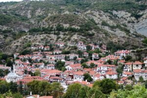
Uçhisar is a town in the Merkez district of Nevşehir province, in Cappadocia. It stands on the Nevşehir–Göreme road, five kilometres from Göreme. The castle’s address is Tekelli Mahallesi, Uçhisar, Nevşehir. These place names locate the rock fortress within a settlement that developed around it.
The settlement’s elevation is given as 1,270 metres above sea level. This figure describes Uçhisar’s elevation. Cappadocia Geopark separately identifies the castle’s location as Cappadocia’s highest point. Keep those descriptions distinct when you read about the height of the town and the prominence of its castle.
The older settlement grew around the castle rock. Newer development spread closer to the Nevşehir–Göreme road. This arrangement connects the history of the inhabited rock with the shape of the town. The castle remained the centre of the older settlement, while another part of Uçhisar developed beside the road.
Uçhisar Kalesi: how the carved castle works
Uçhisar Kalesi is the Turkish name for Uçhisar Castle. Its larger rock mass is called Ağanın Kalesi. The smaller one is Çavuşun Kalesi. These names distinguish the two adjoining formations that together make up the castle, rather than identifying two separate castle sites elsewhere in the town.
Inside, rooms cut into the Kavak ignimbrite connect through stairs, tunnels and passages. Sefa Özkan’s cadastral study describes rooms, stairways and living spaces created by carving the natural rock. The castle’s internal layout therefore depends on excavated space within the formation. Its history can be read through these connections between rooms.
Millstone-shaped doors stand at room entrances and controlled access. Their position gives a concrete detail to the castle’s defensive use. Movement depended on passages and thresholds within the rock. Erosion has since made some rooms inaccessible, so the spaces that can be reached do not represent the entire carved interior.
Uçhisar Castle history: when did its use begin?
The Ministry of Culture and Tourism’s visitor page traces the use of the castle’s carved spaces to the Roman period. Its cultural inventory offers a different kind of dating. It places the probable carving of the defensive spaces in the eighth century, during Arab raids. That is a proposed date, not a certain foundation year.
These statements concern different aspects of the site. Roman-period use refers to the carved spaces. The eighth-century proposal concerns their formation as a defensive place. You can distinguish occupation from defensive development without assigning the entire castle to one construction date. The surviving rock contains a history of use, rather than a single securely dated building campaign.
During the twelfth to fourteenth centuries, the castle continued to serve surveillance and defence under the Seljuks and the Beyliks. This recorded function gives a clearer medieval stage in its history. The high rock was a place from which the surrounding area could be watched, while its carved interior provided defensive spaces.
The name Uçhisar also has alternative explanations. One account links it to being the outermost of three castles. Another connects it with a frontier castle between Kadı Burhaneddin and the Karamanoğulları. These remain alternative accounts of the name. Neither needs to be treated as a proven explanation for the castle’s origins.
Timeline
- Roman period: The Ministry’s visitor page traces the use of the carved spaces to this period.
- Eighth century: The cultural inventory suggests a probable date for carving the defensive spaces during Arab raids.
- Twelfth–fourteenth centuries: The castle served surveillance and defence during the Seljuk and Beylik periods.
- 1530: A population count recorded approximately 3,000 people in Uçhisar.
- 1960s: Residential use inside and around the castle continued into this decade.
- 1974–1977: Cadastral work began in July 1974, finished in 1976 and led to land-register registration in 1977.
- 2 July 1987: Cultural-property registration was recorded under decision number 3446.
- 2000 onward: Many old stone houses in Uçhisar were converted into hotels.
Homes, stores and dovecotes around the castle
The approximately 3,000 residents recorded in 1530 belonged to Uçhisar as a settlement. That population figure should not be read as the number living inside the castle. Residential use nevertheless continued within and around the rock until the 1960s. The castle was part of an inhabited town across a long span of time.
The cultural inventory records that traditional houses around the castle were evacuated because rock masses cracked and fell. Erosion also prevents access to every castle room. These details connect the shape of the rock with the changing use of its spaces. Habitation depended on a formation that continued to fracture and wear away.
Rock masses and fairy chimneys around the castle also served as stores for grapes and potatoes. Here is an everyday-life connection: the historical landscape included the practical task of keeping food. Alongside rooms associated with defence, the surrounding rock held produce used in ordinary household life.
Many rooms on the castle’s northern side were used as dovecotes. Güvercinlik Valley, which extends between Uçhisar and Göreme, also contains rock-cut dovecotes along its slopes. Together, these recorded features place the castle’s carved rooms within a wider landscape of excavated spaces serving different purposes.
Uçhisar Castle summit: what survives?
The summit contains rock-cut graves and a large cistern.
Two rock-cut church remains are recorded around the castle. Their presence adds religious spaces to the homes, stores and defensive rooms associated with the site. The castle and its immediate surroundings therefore preserve several kinds of activity. The graves, churches and cistern belong in an account of its history alongside the passages and doors.
Details you won’t find in guidebooks
The two named rock masses also appear separately in cadastral records. Sefa Özkan’s study identifies Ağanın Kalesi as parcel 14275 and Çavuşun Kalesi as parcel 14276. This administrative detail connects the familiar outline of the castle with the modern recording of land and property.
The same study records a survey pillar at the summit. Its cadastral number is 396, and its planning number is 35. Alongside the summit’s graves and cistern, this pillar belongs to another phase of the site’s history: the measurement and registration of the castle landscape.
Land registration and cultural-property registration occurred at different times. The castle entered the land register in 1977, following the cadastral work begun in 1974. Its cultural-property registration is recorded as decision 3446, dated 2 July 1987. These dates describe separate administrative events in the castle’s recent history.
Uçhisar kaya otel: old houses and changing accommodation
Many of Uçhisar’s old stone houses have been converted into hotels since 2000. This change belongs to the history of the settlement around the castle. Buildings associated with the older town acquired accommodation uses, adding another stage to a landscape already shaped by habitation, storage and defence.
FAQ
How old is Uçhisar Castle?
The Ministry of Culture and Tourism’s visitor page traces the use of its carved spaces to the Roman period. Its cultural inventory suggests that defensive carving probably dates to the eighth century. Neither statement establishes a single certain foundation date.
Did people live in Uçhisar Castle?
People lived inside and around the castle until the 1960s. The cultural inventory records that traditional houses around it were evacuated because rocks cracked and fell.
Sources
- Turkish Wikipedia — Uçhisar, Nevşehir tr.wikipedia.org
- English Wikipedia — Uçhisar en.wikipedia.org
- Ministry of Culture and Tourism, Culture Portal — Uçhisar Castle kulturportali.gov.tr
- Cappadocia Geopark — Uçhisar Castle kapadokyajeopark.com.tr
- Ministry of Culture and Tourism, Culture Portal — Uçhisar Castle Cultural Inventory kulturportali.gov.tr
- HKMO — Sefa Özkan, Uçhisar Kalesi ve Kadastro kurultay.hkmo.org.tr
Image: Uçhisar, Cappadocia 01.jpg — Bernard Gagnon, CC BY-SA 3.0